Chapter 8 – Coasts and Sea-Level Changes
Coasts and Sea-Level Changes
Learning Objectives
Welcome to Chapter 8. At the end of this chapter you will be able to:
- Identify the factors that can determine the type of coast you will find in any given area.
- Identify the source of energy for movement of sand onto and off of beaches
- Describe the processes that are performed by the in-and-out movement of the sand with every wave.
- Explain the differences between a “winter beach” and a “summer beach” with regard to sand transport.
- Define longshore drift and the net movement of sand.
- Describe how 3mm of sea level rise will vary between a rocky mountainous coastline and a shallow sandy coastline.
- Identify policy implications of sea level rise for a barrier island town like Port Aransas, Texas.
- Describe the engineering techniques used to stabilize or create beaches, their benefits, and their drawbacks.
Coasts and Cape Cod
The author, Dr. Alley, is a lucky fellow. Through a fortuitous sequence of events, which involved marrying the right woman who had the right grandfather who was related to some people who have roots in the right place and worked to preserve those roots, our family has been able to occupy a room in the smallest of three houses in a “compound” in Eastham on Cape Cod for a couple of weeks during many summers. The land now belongs to the National Park Service as part of the Cape Cod National Seashore, but the houses were “grandfathered” and remain in the extended family. The bicycle trail to the Coast Guard Beach crosses the driveway, the Salt Pond Visitor Center is just around the corner, and the boat houses face Salt Pond Creek that opens on the Nauset Marsh.
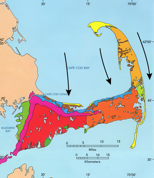
Cape Cod is a glacial moraine. The part that attaches to the mainland marks the end of a lobe of the Canadian ice sheet. The “forearm” where the Cape points north is an interlobate moraine—while one glacier lobe filled Cape Cod Bay between the Cape and Boston, a second lobe lay farther east in what is now the Atlantic Ocean, and built a moraine that is now the fertile fishing grounds of the Grand Banks. (You will see this when you reach the geologic map later in this section.) The forearm of the Cape was deposited mostly by meltwater rivers flowing off these two ice lobes into the narrow space between them (more till is found along the “upper” arm of the Cape where it first projects out from the “mainland”).
This forearm part of the Cape thus is an outwash plain, and most of the numerous freshwater ponds of the Cape began their lives as ice blocks buried in outwash gravels. Melting of the ice later allowed collapse of the gravels on top to form these kettle ponds. Soon after it formed, the Cape had more ponds than we see today, but many have been filled with logs, sticks, leaves, peat, and other organic material. The logs and other materials in these former kettle ponds can often be seen weathering out of the bluffs along the Atlantic beach, including along the Coast Guard Beach that is so easily reached from the Salt Pond Visitor Center of the National Seashore. Radiocarbon dates on such deposits show that the ice was retreating from the Cape Cod region by roughly 15,000 years ago.
The sandy soils of the Cape, and its numerous kettle ponds, are home to cranberries, blueberries, and wild orchids. Beach plums produce their small but sweet fruit late each summer, and blackberries and dewberries vine across old dunes. Deer and grouse still inhabit the uplands, and turkey are multiplying rapidly as oaks spread across regions that were logged by humans but are being allowed to regrow.
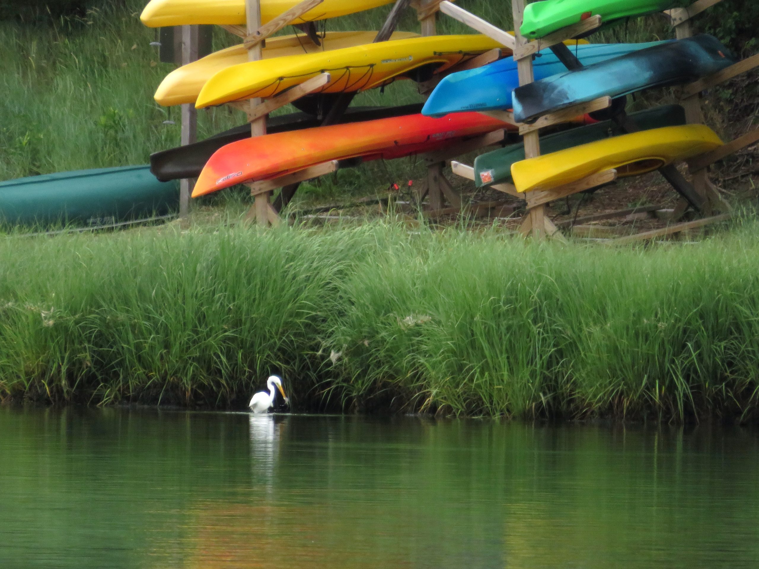
Much of the interest at the Cape focuses on the sea. Nauset Marsh, for example, is miles long and a good chunk of a mile wide. The marsh is protected from the open ocean by the “outer beach,” a long sand bar that is split by one inlet or occasionally more inlets (depending on what year you visit). Behind the outer beach, the marsh is a tidewater environment, filled and then largely emptied by the flow through the inlet. Deep channels are home to crabs, scallops, starfish and striped bass. Between the channels, great flats of marsh grass flood during high tides and dry as the tide falls. Legions of herons and egrets stride the grass, and myriad shorebirds roam the beaches and mud flats. Osprey survey the marsh from high nests on perches constructed by the Park Service.
One year, a hurricane to the south had spun unusually warm waters and great swells to the Cape, and the marsh filled with ctenophores. Also called comb jellies, and looking something like jellyfish, these creatures appear opalescent in the sun because the light is broken on the cilia or hairs that the creatures beat to move themselves about. At night, this particular type (Leidy’s comb jelly) is bioluminescent. Imagine, if you can, kayaking into the marsh after dark, with golf-ball-sized fireflies of the ocean glowing and swirling with every wave. Another year, phosphorescent dinoflagellates were blown into the marsh, and the glow was everywhere rather than just in the ctenophores, with every drip from the kayak paddle lighting up, and fiery baitfish skittering across the surface, pursued by the glowing bulk of predatory stripers. Indeed, a wonderful place.
The Cape is changing rapidly, however. The large Nauset Marsh, between Orleans and Eastham, has been narrowing as the outer beach moves steadily into the marsh. Two of the Cape’s lighthouses were moved during the summer of 1996, barely in time to avoid collapsing over the bluffs into the sea as the bluffs have been eroded away.
At the ends of the Cape, to the north and south, new land is being formed as sand is deposited (yellow on the map below). But, more than twice as much land is lost each year as is formed, and the Cape is slowly but surely disappearing. With the next ice age to rebuild the Cape still far in the future, the Cape appears destined to become islands and then an undersea bank over the next few thousand years. The long-term retreat rate of the Outer Beach in Eastham has been about 3 feet per year over more than a century, with fluctuations but perhaps with a little recent acceleration.
Waves and Coasts
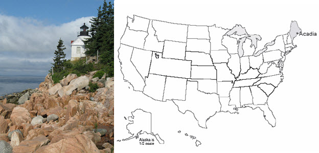
There are many types of coasts. North of the Cape at Acadia National Park, Maine, strong igneous and metamorphic rocks make sea cliffs. South, in the Virgin Islands National Park, are coral reefs. Built from the skeletons of millions of tiny animals, the reefs rise from the sea bottom and flourish in shallow, clear, sunlit, oxygenated waters far from sediment that would bury and choke them. Around into Louisiana, you remember the Delta National Wildlife Refuge, and the miles of waterfowl-filled wetlands on mud delivered by the Mississippi River. At Cape Cod, we find barrier beaches or barrier islands offshore of marshes, or we find sandy beaches with the bulk of the Cape just behind.
The type of coast depends on the supply of sediment to it, the wave energy, the tidal range, the type of rocks, and many other factors. Here, we will concentrate on the Cape Cod sandy beaches.
Watch a wave on the Cape, or any other sandy beach, and you will see that the wave moves a lot of sand. Dig a hole just above the water level during a rising tide, and within a few minutes the hole will be filled with wave-carried sand. Go to the beach during a big storm and you will see immense amounts of sand moved. Hundred-foot-high bluffs may be eroded back several feet, or layers of sand many feet thick may be added to the beach or eroded from it in hours. A movie at the Salt Pond Visitors Center includes a series of photos taken of one section of beach before and after a string of storms one winter. The summer beach is an unbroken expanse of sand, but boulders many feet across are buried in it, and were completely covered and uncovered several times during that one winter as the sand was moved on and off the beach.
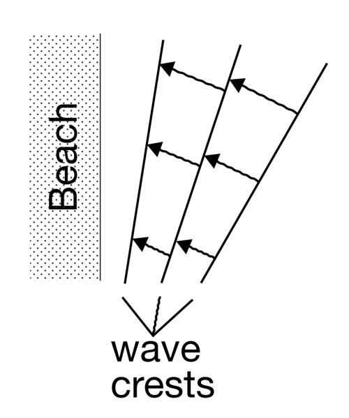
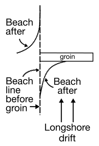
The energy for all of this comes from the wind driving waves, and to a lesser extent from the tides. Most of the sand transport is simply onshore and offshore with each wave—the sand is carried in as a wave comes in, and out as the wave goes out. Most transport is to and from the beach, rather than along the beach, because most waves turn so that their crests are almost parallel to the beach, and their water motion is almost directly towards and away from the beach. The turning happens because waves go slower in shallower water. If a wave approaches a beach at an angle, the first part to near the beach will slow down, allowing the rest of the wave still in deep water to nearly catch up, as shown in the diagram to the right.
Every wave moves sand up and down the beach. On even rather quiet days, if you sit down on a Cape Cod beach in shallow water, you soon will find that sand is piling in places around you, and being eroded in other places, and that you have sand in your swim suit, and possibly even in your hair. This in-and-out movement of the sand with every wave dominates the sand transport, allows for very efficient sorting of the sand by size, and serves to knock the sharp edges off sand grains, sea shells, old soda bottles, and other material on the beach.
Look out to sea during a winter storm, and you’ll see high-energy breakers coming at you. The white caps of the waves rise high, curl over and crash down, so that some of the water arrives on the beach after coming in through the air rather than washing along the sand. But the water then rushes back toward the ocean along the sand, carrying some sand seaward. There thus often is a little net movement of sand from the beach into slightly deeper water during storms, which are more common during winter than during summer. This transport may remove enough sand to lower the beach many feet or tens of feet during the winter, exposing buried boulders. The waves of summer are on average lower in energy, and don’t break and travel through the air as much (occasional hurricanes change this story, but most of the time the story is fairly accurate). The surge of summer waves up the beach is slightly faster than the return flow down the beach, and may carry a tiny bit more sand up than back; the net effect is to bring sand from just offshore back to the beach, burying any beach boulders that were exposed during the winter.
But, the incoming waves do not turn quite enough to come straight in, as shown in the diagram—they still have some angle. If you ride the waves in, swim out, ride in, swim out, ride in… after a while you will find you have drifted down the beach away from the lifeguard—even though you were mostly going toward the beach and back out to sea, the waves also were pushing you sideways. In such a situation, we say that you are experiencing longshore drift—you, and the water, and sand, are moving along the shore. Eventually, when the water and sand reach the end of the Cape (at the Provincelands to the north, or Monomoy to the south), some of the sand builds a spit or extension of land, but some of the sand is dumped off into deeper water beyond the reach of waves. This sand is then lost from the Cape, and the Cape has gotten a little smaller. Most references say that the great beach facing the Atlantic is retreating at about 3 feet (1 m) per year, although it may have been a little faster recently, and the panicked light-house rescues were required because retreat for a few years was much faster. We’ll look at these issues, and what might be done, after visiting Acadia in the next chapter.
Acadia and Sea-Level Rise
The subduction and collision with Europe during the closing of the proto-Atlantic made great granite bodies draped in metamorphosed sediments, and we find these exposed along the Maine coast. Much later, the glaciers scoured those rocks clean, leaving the bald mountain tops of what is now Acadia National Park, staring out at the storm-tossed north Atlantic across Somes Sound, the only fjord on the east coast of the U.S.
The Wabanaki tribe of Native Americans probably reversed the modern tourist pattern, summering inland and then moving to the relatively more moderate coast of Acadia in the winter. Nasty winter storms do run up the coast, but the temperatures plunge far lower inland than they do on the coast. Thick piles of discarded shells of nutritious sea creatures dating back 6000 years attest to the importance of the sea to these early people.
On September 5, 1604, the French explorer Samuel de Champlain landed on Acadia’s island. Impressed by the bare, rocky, deserted appearance of the glacially scoured granite mountain peaks of the island, he named it Isles de Monts Desert.
French influence was important until the end of the French and Indian War, after which English and then U.S. activity came to dominate. In the mid-1800s, Mount Desert Island attracted the art world, and was featured in paintings by Frederic Church, Thomas Cole and others of the Hudson River School (for example, have a look at Twilight: Mount Desert Island, Maine by Frederic Edwin Church(link is external). The artists, in turn, attracted the “rusticators,” tourists who gradually were replaced by much wealthier tourists who built summer “cottages”—the Rockefellers, Fords, Vanderbilts, Carnegies, etc. These wealthy patrons in turn invested resources and political capital in preserving most of the island as a national park.
Today, over 4 million visitors per year flock to Mount Desert Island, with most of them getting out of the gift shops and into the national park. The visitors enjoy the history, the beauty, the rather chilly ocean waters (based on personal observation by the author, even on hot summer days, there is more sitting by the sea than swimming in it!), the outstanding network of paths for bicycling, superb kayaking on lakes and sea, and much more.
Changing Coasts and Sea Levels
Change is the only constant on coasts. The Sea Grant Program at the Woods Hole Oceanographic Institution, on Cape Cod, reported that about 75% of the U.S. coastline is eroding, with only about 25% stable or advancing. For Massachusetts, 68% of the coastline is listed as eroding, 30% advancing, and a mere 2% stable.
Up in Maine, the rocky parts of Mt. Desert Island are among the few places that would be classified as “stable,” although very slow erosion is occurring as the sea pounds the granite headlands. But if you look further back in time, the size of the changes becomes evident. Glacial ice overran the highest peaks in the park during the ice age. Sea level was lowered 300-400 feet (100 m or a bit more) at that time to supply the water that grew the ice sheets, but the land of Mt. Desert Island was pushed down 600-700 feet (roughly 200 m) or even more by the weight of the ice.
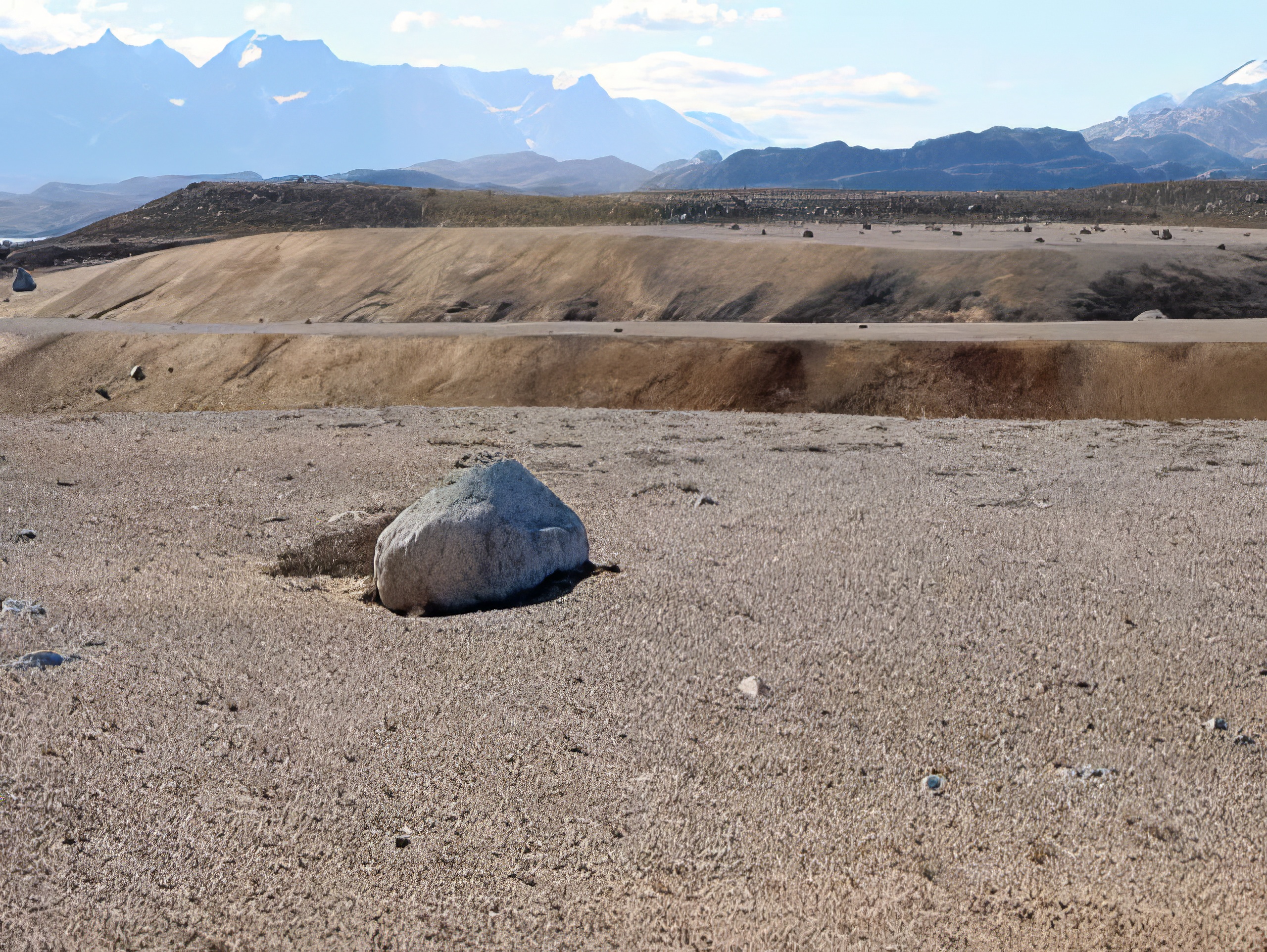
Ice farther south began melting before the ice on Maine, so the sea began rising, but then loss of ice on Maine caused its rocks, including Mt. Desert Island, to begin rising faster than the sea. The rising of the pushed-down rocks is slow, and in fact is still going on today. Thus, as the ice retreated, the already much-raised sea first flooded in across broad regions of Maine and adjacent parts of the east coast. Beaches and sea caves formed, and deltas were deposited. Then, these coastal features were raised out of the ocean as the land rebounded. Such coastal features can be found today in Acadia to almost 300 feet (almost 100 m) above the modern sea level, and similar features occur all along coastal Maine. We include a picture of a similar delta from Greenland; the features in Maine are covered with trees and houses and roads and such, and although the features are quite easily identified by experienced geologists, the features are not as clear as those in Greenland to the beginning geologist.
Regions that were slightly beyond the reach of the ice-age glaciers were pushed up in a forebulge, when the hot, soft, deep rocks pushed out from beneath the sinking ice sheets bulged up the land just before the ice. In those forebulge regions, the land now is sinking, as the deep, hot rocks flow back to their starting point; where forebulge sinking has combined with rising sea level as the ice melted, the total sea level rise has been especially large. Far from the ice sheets, sea-level rise has been about what you would expect based on the amount of water returned to the ocean by the melting ice sheets (although the entire surface of the Earth was warped by shifting water from the oceans to the ice sheets and back, so the changes are all a bit more complicated than you might expect, just as a wine glass balanced anywhere on a cheap water bed will tip over if you sit anywhere on the bed).
By now, you may be getting the idea that what happens to a particular coast is fairly complex. If mountain-building is pushing the coast up, it rises; if mountain-building is pushing the coast down, it sinks. Where plates meet, when the edges are locked and building toward an earthquake, the motion may drag one side down and push the other side up; the earthquake that follows will suddenly reverse the offset—in the great Tohoku earthquake of Japan in 2011, parts of the Japanese coast moved as much as 8 feet toward North America, and offshore the largest motions of the sea floor were more than 150 feet horizontally and more than 20 feet vertically. Where cities are built on deltas, as at New Orleans, the compaction of the mud causes sinking. Much additional sinking is caused by pumping water or oil or gas out of the ground; as the fluids are removed, the ground compacts. This is happening a little on Cape Cod, and is quite dramatic in some places. Groundwater pumping may have contributed to problems at New Orleans, in Venice, and elsewhere. (Reinjection of fluids can partially offset this problem, and is being used in some places.)
Additional complexity comes from the issues of sediment supply. Beaches inevitably lose a little sediment to deep water, somewhat like losing socks behind a clothes dryer, because it is easy to drop something that falls way down there, and hard to get it back. Waves affect sediment below the surface, but only down to a depth that equals roughly half the distance between a wave’s crest and the next one. If sediment happens to slide or bounce deeper than the depth reached by the deepest-reaching waves, then that sediment cannot be brought back easily. (The sediment can go into a subduction zone, be taken down and scraped off, or else melted and erupted and loosened by weathering and landslided and transported in a river and then in longshore drift to the beach, but that takes a long time.) And, longshore drift moves a lot of sediment, but eventually the sediment often encounters an undersea canyon and drains down to deeper water below the reach of waves.
Thus, a “happy” beach requires a supply of sediment to balance the loss to deep water. Normally, that supply comes from the material delivered to deltas by rivers, and carried by longshore drift. But if there is not enough sediment coming in this way, the beach will narrow as it loses sediment to the deep ocean, and the waves will reach across the sand to erode the material behind, gaining sediment in this way.
In those cases when longshore drift does not supply enough sand to make a beach, and the waves are battering on the coast, if the rocks are really hard, like the granite of Acadia, then there won’t be a beach at all, with the tiny bit of material eroded from the granite quickly dumped into deep water. (There are a few small “pocket” beaches at Acadia in protected places, but most of the coast doesn’t have beaches, with granite sticking right out into the waves.) If the coast is sand and gravel left by the glaciers, as seen at Cape Cod, the waves cut the coast back and supply that material to the beaches.
In some places, dams on rivers have greatly reduced delivery of sediment, so the coasts are eroding. You may recall that the dams on the Elwha River, draining Olympic National Park, caused loss of beaches along the coast. At Cape Cod, there really aren’t any rivers to dam. The glaciers made a big pile of sediment in a place where rivers are not supplying much sediment to deltas, and so the Cape eventually will be lost to deep water.
Rising Sea Level and the Future
So coasts change for many different reasons, and in many different ways. But, recently, most of the U.S. (and world) coasts have been retreating because sea level is rising, and that rise is accelerating.
The rate of rise has been about 2 mm/year (just under an inch per decade) over the last century, but seems to have sped up to about 3 mm/year (a bit over an inch per decade) recently. That isn’t much if you’re at the top of a cliff in Acadia, but if you are on a sandy beach that slopes very gradually, the inch of sea-level rise may cause many feet, or even a few tens of feet, of coastal retreat. That in turn means that a whole lot of houses and property can be lost in a single lifetime.
The ongoing sea-level rise is being caused primarily by the global average warming of the last century, which is being driven primarily by human activities (we’ll return to this later, but we have high scientific confidence that it is correct). Most of the world’s small glaciers have been melting this century, returning water to the oceans. Also, as the ocean itself warms, the water expands and takes up more room.
Two other possible causes of sea-level change are humans “mining” groundwater, and melting or faster flow of the polar ice sheets. We build dams on rivers, and the water that fills the reservoirs is taken out of the ocean and stored on land, causing sea-level fall. But, we “mine” groundwater by pumping it out of the ground faster than nature puts it back, in places such as Phoenix, Arizona where green yards and golf courses and fountains seem to “need” LOTS of water, and that water eventually reaches the ocean to raise sea level. Today, groundwater pumping is probably more important than dam building, contributing a little to sea-level rise.
The polar ice sheets contain a huge amount of water—if they melted, they would raise sea level nearly 250 feet (roughly 70-80 m). Philadelphia and the other great port cities of the world would become undersea hazards to shipping but really great places for fish to hide out, and the southern coast of Florida would be somewhere up in Georgia. We do not expect such a fate within at least the next few human lifetimes, but we cannot rule out the possibility that a dynamic collapse of the West Antarctic ice sheet could raise sea level 10-20 feet (3-6 m) in a human lifetime or two, and if we don’t change our behavior over centuries, Greenland and its 24 feet of sea level is looking shaky. Drs. Anandakrishnan and Alley spend a lot of their research trying to reduce our uncertainty about the future of the great ice sheets, a fascinating and important topic.
The near-certainty of continuing sea-level rise has some policy implications. For example, disaster aid following hurricanes that allows people to rebuild in coastal regions will simply create the need for more disaster aid in the future. Many people believe that those who wish to build on the coasts should be required to carry insurance to cover their coming losses. Similar arguments apply to those who wish to build on earthquake faults, landslide deposits, and floodplains. Why should those living in relatively safe but less-scenic places pay for others to live in dangerous but beautiful places?
Because people love the coasts so much, and wish to live near them, all sorts of engineering solutions have been tried. One is to build “dams” (usually called “groins” if they are small, or “jetties” if larger) that stick out into the water and block the longshore transport of sand (see figure to the left). By making the coast rougher, and slowing waves, the plan is to trap sediment along the coast the way a dam traps sediment along a river. This plan sometimes works. However, recall that in a sand-bedded river, sediment is trapped upstream but eroded downstream. The same often happens along a coast; sediment is trapped “upstream” of the groin (on the side from which the longshore drift comes), but sediment is eroded on the “downstream” side (the side to which the longshore drift goes), where the sand-free waves attack the beach to pick up more sand. Saving someone’s beach while destroying the beach of a neighbor is a good way to generate lawsuits. People also spend millions of dollars to go out to sea, find sand that has fallen off into deep water, and bring the sand back to the beach. This sand usually lasts a single year or a very few years before being washed back to deep water, but in especially popular tourist destinations, the investment may pay off.
Geologists often take a “natural” view of the coasts—we should figure out where the coast wants to go, and build there rather than trying to stop the coast. But many people just don’t like that, and a lot of construction is likely to occur—and be destroyed—over the years.
Optional Enrichment Article
Wishing for Water – When Salt and Fresh Mix
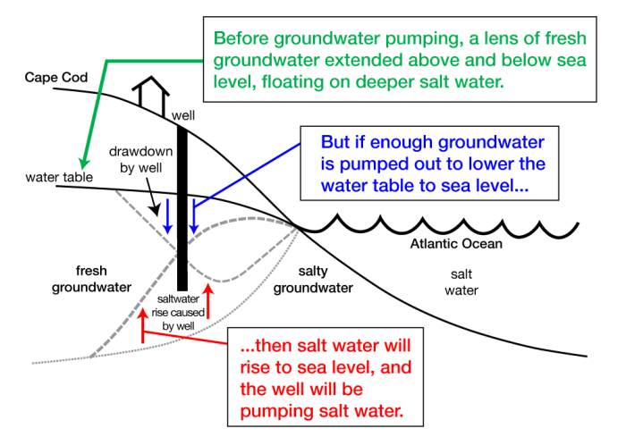
Groundwater pumping also can cause saltwater intrusion. Fresh water has lower density than salt water, and so floats on salt water in the same way that an iceberg floats on water. (Salt and fresh water will mix, but if the fresh water is renewed by rainfall, the mixed waters will be forced out through the beach to the ocean, and there will continue to be nearly pure fresh water sitting on salty ocean water.) If the water table is lowered by pumping fresh water for human use, the interface between salt and fresh water will rise in the same way that the bottom of an iceberg or a mountain range rises if the top is eroded. The difference in density between salt and fresh water is small; an iceberg floating in the ocean has 9/10 of its thickness below the surface, but the fresh groundwater lens of Cape Cod floating on ocean water has 39/40 below sea level. So if enough water is pumped out of the well to lower the water table 1 m, the salt water will have risen 39 m! If the fresh water table is lowered to sea level, the salt water will rise to sea level, and there will be no fresh water left at that point. Many wells on the very low land of Cape Cod were drilled below sea level into fresh water, but are starting to pump up salt water, causing large problems.
Key Takeaways for Coasts and Sea-Level Changes
Getting the Most from the Coast: Cape Cod, Acadia, and Friends
- There are many coast “types” (beach, reef, mud flat, cliff, delta, etc.
- Waves move LOTS of sand, which sorts by size to create sandy beaches.
- Waves move a little extra sand out during winter storms (breaking waves come in through air without sand, go out along surface with sand).
- Move a little extra in summers (surge up the beach a bit faster, moves a bit more than return flow).
The Coast Is Friendly–the Ocean Waves
- Waves go slower in shallower water;
- Come in at a slight, driving longshore drift of sand and water;
- Eventually, some sand is lost to deep water below the reach of waves;
- Beach needs sediment supply to balance this loss.
The Coast Is Friendly–Buoy Meets Gull
- New beach sand by longshore drift from river-fed deltas;
- Or by erosion of coast behind beach;
- Lose longshore drift from river-fed deltas by
- dams on rivers (Elwha dams in Olympic caused beach loss);
- “dams” along the coast (jetties or groins that stick out, block drift to trap sand, let clean water pass to erode beyond);
- past sea-level rise, flooded river valleys so sediment fills bays and doesn’t reach outer beaches (e.g., Chesapeake);
- past deposition (especially by glaciers) forming coastal land (e.g., Cape Cod) without big rivers to supply sand.
But many coastal residents are crabby
- Most U.S. coasts retreating (about 75%);
- from past sea-level rise and glaciation, dams and coastal modifications
- from sea-level rise now (from warming expanding water and melting ice, plus groundwater mining, with worries about the future of huge ice sheets);
- from pumping of groundwater, oil and gas allowing compaction and sinking;
- Regions pushed down by ice-age ice may be rising; those bulged up before ice-age ice sink faster
