Chapter 7 – Glaciers, Ice, and Permafrost
Glaciers, Ice, and Permafrost
Learning Objectives
Welcome to Chapter 7. At the end of this chapter you will be able to:
- Define a glacier and describe under what conditions it forms.
- Describe the two ways in which glaciers move.
- Explain how ice can flow internally, even though it is a solid.
- Explain how glaciers weather and erode sediment
- Analyze and give examples of how glaciers can be both part of the hydrologic cycle and part of the rock cycle.
- Determine the primary agents of weathering and erosion in The Grand Canyon of Yellowstone versus Yosemite Valley based upon the valley shape.
- Identify erosional and depositional features created by glaciers
- Identify the evidence for past ice ages.
- Describe how we can determine how many ice ages have occurred.
- Analyze the information on ice ages and identify the controlling factors on the formation of an ice age.
- Define permafrost and describe the main type of slow mass wasting that exists and is unique to areas of permafrost.
- Describe the risks of human activity, such as building and heating a home in an area of permafrost.
What Glaciers Do, Erosion and Yosemite
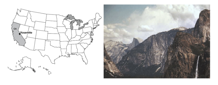
When your tour guide, Dr. Alley, was a much younger man (the year he graduated from high school, 1976), he traveled with his sister Sharon and cousin Chuck on a camping tour of the great national parks of the American west (in Chuck’s 1962 Ford Galaxy 500 land boat). At Yosemite, they hiked from the valley up to Glacier Point. The trail switch-backs up the granite cliffs, opening increasingly spectacular panoramas across the great valley of the Merced River. The view from Glacier Point, across the side of Half Dome, and the thundering Vernal and Nevada Falls, is well worth the climb. It was here that John Muir helped convince President Theodore Roosevelt of the need for a National Park Service to care for the National Parks, which were protected by law but not by rangers for some decades after the parks were established.
The hikers were a bit disheartened by the crowd at Glacier Point—the view is also accessible by the Glacier Point Road. While they sat and lunched, a tour bus pulled in. Most of the passengers headed for the gift shop, but three settled at a picnic table while a fourth strolled over to the railing to see the scenery for a few moments before joining the others at the picnic table. One of the quick-sitters asked “Anything out there?” To which the ‘energetic’ one replied “Nah, just a bunch of rocks. Let’s go check out the gift shop.” At last report, the gift shop had been removed. Regardless, it must be a sad person indeed who would not walk 50 feet to see the glory of Yosemite.
To anyone with open eyes, Yosemite Valley—the “Incomparable Valley”—is well worth inspection. It is carved from the granites and similar rocks of the high Sierra Nevada of California. Once, this granite was magma (melted rock below the surface), far beneath an earlier mountain range. The magma may have fed subduction-zone volcanoes much like those of the Cascades, which continue to the north of the Sierra. However, stratovolcanoes along this part of California have died as the East Pacific Rise spreading center ran into the trench along the west coast, forming the San Andreas Fault but ending subduction. Such a fate eventually awaits the Cascades volcanoes, some millions of years in the future.
The Sierra Nevada was raised and tilted along the great fault to its east, and looks down on Death Valley and the rest of the Great Basin. Earthquake activity, and faults cutting recent sediments, show that the mountain range is still being lifted above the still-dropping Great Basin.
The tough granite of the Sierra Nevada is more resistant to weathering and erosion than are most rocks, but granite does eventually break down, and some streams have managed to exploit weaknesses and cut deep channels through the range. These streams include the Tuolomne River, which carved the mighty Hetch Hetchy valley, now dammed so that a valley the equal of Yosemite is lost under water. The Merced River, which runs through Yosemite Valley, also cut into the range.
The stage was then set for the ice ages. Glaciers gathered on the high peaks, flowed into the valleys, and began to change the landscape.
Which Way Did It Flow?
A glacier is a mass of snow or ice that deforms and moves. Glaciers form wherever snowfall exceeds melting over enough years to make a pile big enough to flow. In places with extremely high snowfall, this can occur where average temperatures are near or even slightly above freezing, such as on the mountains of the Olympic Peninsula. In dry places, glaciers may be absent even if average temperatures are well below freezing. Such places have frozen ground instead, called permafrost (because the frost is permanent).
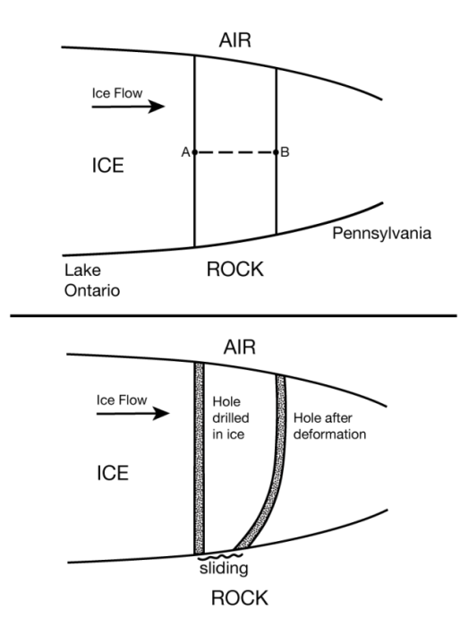
A pile of pancake batter spreads across a griddle, moving away from where the upper surface of the pile is highest. In the same way, a glacier moves from where its upper surface is highest to where its upper surface is lowest. In the figure below, the pressure at point A (the weight of the material above point A) is larger than at point B, because there is more ice above A than above B. The higher pressure at A gives a net push from A to B. Whether the diagram shows pancake batter, or the ice sheet on Antarctica, this push causes the material to deform and flow.
If you make a pile of pancake batter on a waffle iron, some of the batter may flow along the low grooves and then move up to cover the bumps, but the flow will always move away from the place where the upper surface of the pile is highest. In the same way, ice can flow up a hill in the bedrock if the flow is going in the “down” direction of the upper surface. For example, pieces of Canada are strewn across northeast Pennsylvania, and were brought across Lake Ontario and New York by the ice-age ice sheet. Ice at the bottom of that glacier climbed out of the low spot that now is the lake basin, driven by the upper surface of the ice sloping down from Canada to the U.S.
The total imbalance in pushes is larger for thicker ice than for thin. A very thin ice mass will not deform fast enough for the motion to be measured, and so is not considered to be a glacier. Typically, ice thicker than about 50 m (150 feet) will deform and flow, making a glacier.
Look at the second part of the figure. Glaciers move in one or more ways. All glaciers deform internally, like your slow pancake batter spreading on the griddle. A vertical hole drilled in a glacier will deform as shown in the figure. The stresses are largest, causing most-intense deformation (the permanent bending of the hole shown in the figure), in the deepest ice. The upper ice rides along on the deeper ice, so the velocity is fastest at the surface. Some glaciers are at the melting point at the bottom, warmed by heat flowing out of the Earth beneath. These melted-bed glaciers may move over the material beneath them, either by sliding over those materials (shown in the figure) or, if the materials are soft sediment, by deforming those sediments in a sort of slow landslide (not shown).
Recall that rivers adjust to move sediment and water from one place to another. So do glaciers. The water is supplied, frozen, in the accumulation zone, where snowfall exceeds melting, causing snow and ice to accumulate. The frozen water flows to the ablation zone, where melting exceeds snowfall (ablation means wearing away), or else flows to where icebergs break off (called calving) and drift away to melt elsewhere. For ice sheets covering continents or for smaller ice caps covering plateaus or mountain tops, the ice forms a dome and spreads out in all directions. For glaciers on the sides of mountains, the ice flows down the mountain—the upper and lower surfaces of the ice slope in the same direction.
When we talk about the advance and retreat of a glacier, we are referring to the position of its terminus, where the glacier ends by melting or calving. A glacier is advancing when it is getting longer, and retreating when it is getting shorter. Notice that ice almost always continues flowing from the accumulation zone to the terminus whether the glacier is advancing or retreating—retreat occurs when ice loss by melting or calving is faster than new ice is supplied, and advance occurs when ice is supplied more rapidly than it is removed by melting or calving.
Permanent deformation—flow—within ice may seem strange—after all, ice is a solid. But, as for the soft rock of the asthenosphere down in the mantle, or the soft chocolate bar in a hot pocket, or the red-hot horseshoe in the blacksmith’s shop, ice in all glaciers on Earth is nearly warm enough to melt, and so can flow slowly. As a general rule, materials heated more than halfway from absolute zero to their melting point can flow slowly, and flow becomes easier the closer the temperature is to the melting point. For ice, the coldest yearly average temperature on Earth is about eight-tenths of the way from absolute zero to the melting point, so ice at the Earth’s surface is “hot” and is able to flow. For more on this, and on the occurrence of crevasses as well as flow, see the Enrichment.
Glacier Tracks
A glacier frozen to the rock beneath does not erode much. However, thawed-bed glaciers, especially those with surface meltwater streams draining to their beds through holes (something like cave passages, although formed in different ways), can erode much more rapidly than streams or wind erode. Consider for a moment the Great Lakes of the U.S. and Canada. The lakes were carved by glaciers. The bedrock beneath Lakes Superior and Michigan is well below sea level, and was carved that deep by glaciers, not rivers! Today, rivers carry sediment into the Great Lakes, slowly filling them up. We will see later that over the last million years, times when glaciers were eroding have alternated with times when streams were filling the lakes back up with sediment, and the streams have had more filling-up time than the glaciers had eroding time. And yet, there are the lakes, not the least bit full of sediment. Evidently, the glaciers have been much better at their “job” than the streams have been. The same can be said for many other places. It is not too extreme to say that the regions glaciated 20,000 years ago and free of ice today still preserve a glacial landscape.
Ice moving over bedrock “plucks” rocks free, and then uses those rocks to abrade or “sandpaper” the bedrock, scratching and polishing it. As ice flows over a bedrock bump, the side the ice reaches first is abraded smooth while the other side is plucked rough. Subglacial streams sweep away the loose pieces, and may cut into the rock as well.
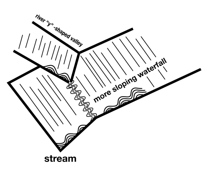
Plucked and abraded rocks show clearly that glaciers were present, but so do big features, as seen in Yosemite and elsewhere. If you could make a cut across a typical stream valley in the mountains, you would see that it usually is shaped like the letter “V”. The narrow stream cuts downward, and then mass-movement processes remove material from the walls, giving a “V”. (Where a V-shaped stream enters an ocean to make a delta, the outward and upward growth of the delta over time may eventually fill the bottom of the V with mud to make a flood plain, as we saw with the Mississippi, but initially, when a stream is cutting down, it makes a V.) However, glaciers are quite wide, and can erode across a broad region. Glaciated valleys exhibit a characteristic “U” shape. Yosemite Valley, with its near-vertical walls and near-horizontal floor, is a classic “U”, not a “V”.
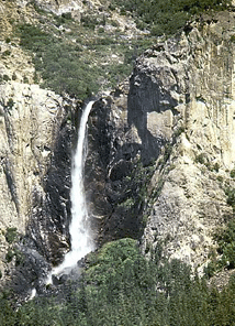
The steeper a stream is, the faster it erodes. If a main river cuts down rapidly, then the side streams that flow into it will become very steep, and will cut downward very rapidly. In this way, even a small side stream can “keep up” with the main stream as it erodes downward, and stream processes usually produce “rapids,” rather than waterfalls where the side streams must plunge over cliffs to reach the main stream. Glaciers are different. A main glacier often fills its valley, the ice burying most or all of the rock. The ice from a side glacier then does not drop steeply down into the main glacier because there is no drop. So the side glacier is not steeper than the main glacier. The main glacier has more ice and rock and water than the side glacier, and so the main glacier erodes down more rapidly. When the ice melts, a “hanging valley” remains—a small stream that replaces the small side glacier must plunge over a glacially carved cliff and then flow across the bottom of the “U”-shaped valley to reach the main stream. Eventually, the side stream will wear away the waterfall. But today in Yosemite, numerous streams emerge from small “U”-shaped hanging valleys to cascade down the glacially carved cliffs—the landscape is pretty much what the glaciers left. (Piles of rocks at the bottoms of waterfalls show that the streams are indeed changing things, but slowly.)

Glaciers make many other erosional features. At the head of a glacier, where freezing and thawing can break rock that is hauled away by the glacier, a bowl can be carved into the side of a mountain. If bowls chew into a mountain from opposite sides until they meet, a knife-edged ridge is left—the Garden Wall of the continental divide in Glacier National Park, which we’ll meet in the next chapter. Where three or more bowls intersect from different sides, a pinnacle of rock is left, such as the Matterhorn of Switzerland. Mountaineers have dubbed the bowls cirques, the ridges aretes, and the pillars horns, and geologists continue to use these terms.
Glaciers also leave distinctive deposits. Streams, waves and wind all sort rocks by size, leaving too-big ones behind and carrying away smaller ones. Glaciers don’t care how big the rocks are that the ice carries, so a deposit put down directly from ice may have the tiniest clay particles mixed in with house-sized boulders. Such a deposit is called glacial till. Till plus glacial outwash (sediment washed out of a glacier by meltwater) may be piled up together in a ridge that outlines the glacier, called a moraine.
Pennsylvania has a Moraine State Park, which features glacial moraines. Cape Cod is a moraine, and a moraine is draped across Long Island, showing some of the places where glaciers from the ice age ended.
Glaciers and Glacier National Park
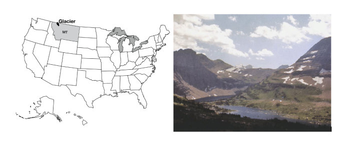
Glacier National Park is the southern half of the Glacier-Waterton Lakes International Peace Park, extending north-south across the Canadian-U.S. border and east-west across the great Front Range of the Rockies. Glacier is wolves and grizzly bears, mountain goats balanced on cliffs, moose munching on water plants, beargrass and avalanche lilies. Going-to-the-Sun Road winds past Going-to-the-Sun Mountain, among the best-named features of the park system. The continental divide snakes along the Garden Wall, in many places a knife-edge ridge left as glaciers gnawed into the backbone of the continent from the east and the west. Long, narrow lakes lie along the valleys, which sometimes host lines of lakes strung like beads on the string of the connecting river. (Such glacier-carved strings of lakes are called paternoster lakes, after a resemblance to the beads of a Catholic rosary.
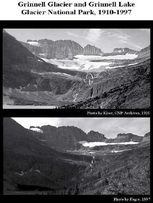
Glacier National Park had roughly 150 active glaciers a century ago, but that is down to 25 or so very small ones, and many of them may be essentially dead now, as modern warmth melts many away (see the changes shown by the older and more-recent photos below). Glacier National Park thus is now more noted for the tracks of past glaciers than for the activity of present ones. But, we suspect that “Ex-Glacier National Park” would not have made the Great Northern Railway happy when they were promoting tourism in Glacier National Park (via the Great Northern Railway, of course). When the last glacier has melted away, perhaps within a few decades (we’ll return to this with the Arctic National Wildlife Refuge, near the end of the course), there are no plans to change the name of the park.
Evidence of Ice Ages
Today, permanent ice covers about one-tenth of the land on Earth, mostly in Antarctica and Greenland, with a little ice in mountainous regions. We saw at Yosemite that glacier erosion and deposition produce features that differ from those produced by mass movement, rivers, wind or coasts. Geologically recent examples of those features, from roughly 20,000 years ago, are spread across almost one-third of the modern land surface—in places such as Wisconsin, and northern Pennsylvania, and Yosemite, and Glacier, and many others, the mark of the ice is unmistakable. The 10,000 lakes of Minnesota, the Great Lakes, the gentle moraines of Illinois, and many more features reveal a landscape that is glacially dominated. Such features in Europe first motivated the hypothesis that ice ages have occurred.
This ice-age hypothesis makes many predictions, which allow testing. In times before modern geology, the glacial deposits were called “drift” because they were thought to have drifted into place in icebergs during Noah’s flood. Other people have suggested that the deposits were splashed into position by a giant meteorite that hit Hudson Bay, and still other hypotheses have been advanced. But, the ice-age hypothesis makes predictions that differ from the Noah’s-flood hypothesis or the meteorite hypothesis in many ways. (The biggest difference is that icebergs and meteorites simply do not make features that even vaguely resemble those actually observed, but let’s look at some other differences.)
If huge ice really existed, its great weight must have pushed down the land beneath—recall that the deep rocks are hot and soft, with a “water-bed” cover of stiffer rocks on top. If the ice age peaked only about 20,000 years ago, the slow flow of the soft, deep rocks should mean that the land would still be rising after the melting of the ice, while land around the former ice would be sinking as the soft, deep rocks return to their pre-ice-age positions. The global-flood hypothesis and the meteorite hypothesis do not predict such a bulls-eye pattern of rising and sinking centered on the regions with features known to be made by glaciers today—the flood would have spread evenly across the land, and so would not have concentrated its weight in one place, and the sudden blast of the meteorite would not have left its weight long enough to push the slow-flowing deep rocks far. Measurements by GPS and other techniques show just the pattern expected from the ice-age hypothesis, a pattern that was not predicted and cannot be explained by the other hypotheses.
The water for huge ice sheets would have been supplied by evaporation from the oceans, with the water getting stuck in the ice rather than returning rapidly to the sea in streams. Hence, if ice ages occurred recently, there should be evidence of lower sea levels at the time the ice was big. No such prediction comes from the meteorite or big-flood hypotheses (the meteorite might have made a wave but otherwise would not have affected sea level; the big flood would have raised sea level). Again, the ice-age prediction is borne out by the evidence, and the predictions of the other hypotheses are wrong. For example, some corals grow only in shallow waters where there is much sunlight. Dead samples of such corals from about 20,000 years ago can be found where they grew, down the sides of islands and now under more than 300 feet of ocean water. Other evidence also points to lower sea level in the recent past—the Chesapeake Bay, for example, is a river valley that was drowned by rising waters.
How Many Ice Ages?—An Ocean of Clues
So, much evidence shows that ice ages occurred. Piled tills separated by soils demonstrate that the ice has come and gone many times. But how many times? On land, the glacial record is somewhat confused—often, an advancing glacier will erode the evidence of a previous one. A pile of four tills separated by soils may record four advances, or forty, with some of the record having been eroded away. In many places in the deep oceans, sediment has been piling up without erosion for millions of years. If there were a marker of glaciation in the marine sediments, we could tell how many glaciations have occurred. If there were a way to date these sediments, we could tell when the glaciation happened. Fortunately, we can identify glaciations using shells in marine sediments, and we can date them. Identifying glaciers from shells is covered here, and learning the age of the shells is coming in the next few units.
Water in the oceans is not all the same—roughly one molecule in 500 has an extra neutron or two in one or more of the oxygen or hydrogen atoms. Such “heavy” water is still water, but weighs a little extra. (If you don’t remember isotopes, go back and have a quick look at the introduction to chemistry near the start of the course.) Not surprisingly, light molecules evaporate more easily than heavy molecules. Water vapor, rain, and snow thus are slightly “lighter” than the ocean; that is, the ratio of light water molecules to heavy ones is larger in vapor, rain, and snow than in the ocean from which the vapor, rain, and snow came.
When sea level drops during an ice age – as water vapor is changed to snow and then to ice sheets, the oceans have lost a lot of water. More light water than heavy water has been lost from the oceans, so the oceans are left a little bit isotopically heavier than normal. When ice melts, that light water from the ice sheets is returned to the ocean and makes it lighter.
These changes are very small. If we round off the numbers a little, we can say that in the modern ocean, 1 of each 500 water molecules is heavy, which is the same as saying that 1000 of each 500,000 water molecules are heavy. When the ice sheets were big, had you weighed a whole lot of molecules in the ocean, you would have found that about 1001 of each 500,000 water molecules were heavy. This is a tiny change, the water was still water, but sophisticated modern instruments are so good that such a change is very easy to measure. (And yes, the instruments actually measure the weight of waaaaaaay more than 500,000 molecules, to obtain good statistics.)
Many plants and animals that grow in the ocean build shells of calcium carbonate (the stuff of limestone) or of silica, both of which contain oxygen. These shells record the isotopic composition of the water in which they grow because the oxygen in the carbonate or silica is obtained from the water. Critters growing during big-ice times grow shells in which the oxygen is isotopically slightly heavy, and critters growing during small-ice times grow isotopically light shells. When the critters die, their shells pile up in layers on the sea floor with the youngest ones on top. A core collected from these sediments is a history of the ice volume on Earth. Just date the core, pull out the shells, analyze them isotopically, and there is the answer. With enough care, knowledge, and instrumentation, dedicated workers can obtain consistent, reproducible data that tell a wonderful, clear story. (There are a few additional details, but the main story is this simple.)
Over the most recent 800,000 years, ice has generally grown for about 90,000 years, shrunk for 10,000 years, grown for 90,000 years, shrunk for 10,000 years, etc. Superimposed on this are smaller wiggles, with a spacing of about 19,000 years and 41,000 years.
The Cold of Space
More remarkable, these cycles were predicted, and not until decades after the prediction did technology become good enough to test the prediction and show that it worked. During the 1920s and 1930s, a Serbian mathematician named Milutin Milankovitch calculated how the sunshine received at different places and seasons on the Earth has changed over long times. As the sun, moon, Jupiter and other planets tug on the Earth, the orbit changes a bit. Earth wobbles with a 19,000-year periodicity, the north pole tilts a little more and then a little less with a 41,000-year periodicity, and the orbit changes from more-nearly round to more squashed or elliptical and back with a 100,000-year periodicity. With modern computers, these changes are relatively easy to calculate for many millions of years; for Milankovitch, the calculation was the labor of a lifetime. (He did it very well, though, even correctly noting that the 19,000-year periodicity really goes from 19,000 to 23,000 years and back, a pattern that is indeed observed in the data testing his prediction!)
These orbital wiggles have little effect on the total sunshine received by the planet, but they do move the sunshine from north to south, poles to equator, or summer to winter in various ways. For example, today the northern hemisphere is farther from the sun in northern summer than in northern winter. (Remember that summer is controlled by the tilt of the planet’s spin axis relative to the plane in which the planet orbits, not by the distance from the sun!) In the few millennia centered on 9000 years ago, the northern hemisphere had slightly warmer summers and cooler winters than recently, because the Earth was closer to the sun during northern summers and farther from the sun during northern winters than today. (Meanwhile, the south had slightly cooler summers and warmer winters than recently, because the Earth was closer to the sun during southern winters and farther from the sun during southern summers than today.) The intense summer sunshine in the north 9000 years ago made mountain glaciers smaller then. As the summer sunshine decreased in the north, those glaciers expanded slowly for several thousand years, culminating in the Little Ice Age of the 1600s to 1800s; strong melting of glaciers since then is probably mostly the result of human-caused warming. (We will discuss this later in the course.)
Summer in the northern hemisphere appears to be key to controlling ice ages, probably because the northern hemisphere is mostly land and can grow big ice sheets, but the southern hemisphere is mostly water, already has ice on Antarctica, and so can’t change its land ice much more. In the north, even during warm winters the highlands around Hudson Bay are cold enough to have snow rather than rain. Survival of this snow requires cool, short summers. As summers have cooled around Hudson Bay, ice has grown; as summers have warmed, ice has melted. The way the various cycles interacted led to larger or smaller changes, and thus to the ice ages we know.
You may guess that this is slightly oversimplified so far. For example, during times when Canada has received reduced summer sunshine, allowing ice to grow, the southern hemisphere or the tropics often were receiving extra sunshine, yet they cooled during many of those times. How Canada told the glaciers of Patagonia and Antarctica to grow was for a long time a great puzzle. The answer involves the global warming from atmospheric carbon dioxide. The growth and shrinkage of the vast ice sheets, the changes in sea level, and other changes had the effect of shifting some carbon dioxide (CO2) from the air into the deep ocean during ice ages, and bringing the CO2 back out to the air during warm times. The orbits affected the ice, which affected currents and sea level and plants and other things, which affected CO2. But, as we will discuss later in the semester, CO2 in the air tends to warm the Earth’s surface no matter how that CO2 got into the air. And, the changing CO2 explains why, when the ice was growing, places getting more sunshine still got colder, and why, when the ice was shrinking, places getting less sun still got warmer.
Climate records show many other types of changes. Very large, rapid changes have been caused by sudden surges of ice sheets, and by jumps in the way the ocean circulates. We do not understand these faster changes well enough to know whether they could happen again, although we’re cautiously optimistic that we won’t have any for a while. Naturally, the Earth’s orbit right now is in an intermediate state, and we should be looking forward to another 20,000 years or more with little change before we begin the slide into a new ice age. (See the Enrichment for a little more on this.) However, humans almost certainly are now more important to the climate than are such slow changes, as we will see later.
Permafrost and Periglaciation – Trail Ridge Road and The Seven Mountains
Meanwhile, what of things back in central Pennsylvania and in the many other places that were not quite reached by the ice-age ice? As you might imagine, with the world cold enough to grow ice to cover New York, Chicago, Minneapolis, and Seattle, as well as much of Europe, the climate was colder everywhere then than it has been more recently.
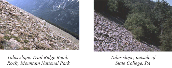
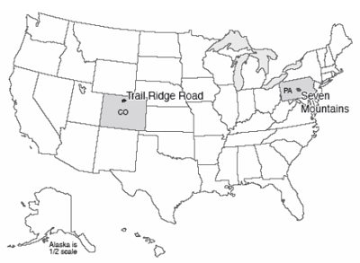
If you climb the ridges of central Pennsylvania, perhaps up in the Seven Mountains just southeast of State College (go up Bear Meadows Road past the ski area, for a start), you may notice several interesting things geologically. Beneath the hemlocks and rhododendron, the soils and streams and hillslopes have more in common with the high meadows of Trail Ridge Road in Rocky Mountain National Park, or with the coast of Greenland, than they do with the modern climate of State College. Trail Ridge Road crosses tundra, where small, hardy plants grow atop permafrost. Although the uppermost soil along Trail Ridge Road thaws during the brief summers, and the deep Earth is thawed by the heat of the Earth, the materials between are frozen year-round in permanent frost. (These areas are also called “periglacial,” because they may occur around the glacier, or on its perimeter.)
Consider the following features of the Seven Mountains.
- Many of the headwaters streams have the braided pattern that forms when lots of big rocks are supplied rapidly. Large rocks are evident across the beds of these braided streams. But, the sediment is not “active.” Trees grow on the bars. Even huge floods, such as the winter flood of 1996, do not move the rocks beneath them. Something in the past delivered much coarse sediment to the streams, and then that delivery stopped. Meanwhile, along Trail Ridge Road today, freeze-thaw processes in the tundra break loose large blocks of rock that can be moved to streams.
- The highest points on the ridges of the Seven Mountains are composed of resistant sandstone bedrock, but near the surface, the rock has been broken into huge blocks, of the sort that are worked loose by freeze-thaw activity. On flat places such as Big Flat, these blocks sometimes are patterned, with higher and lower, coarser and finer regions a few yards (or meters) across. (These features were described by geologists during times when logging and fire had removed the thick vegetation; the features are very hard to see and almost impossible to photograph today, but can be found during careful bush-whacking.) Meanwhile, similar features occur along Trail Ridge Road and in other permafrost regions, where expansion-contraction processes during the seasonal freezing and thawing of the upper layer sort and stir the rocks and soil into such patterns.
- Stripes or fields of sandstone blocks extend from the ridges down across other rock types to the streams. The blocks are often aligned, as they would be in a creeping soil mass. The coarsest blocks typically are on top with finer material beneath, and patterns such as those on Big Flat may be present but elongated as if they were creeping downhill. Yet the blocks are not now creeping downhill; trees grow on top, and have not been knocked over or bent by landsliding or soil creep. Meanwhile, when the top of permafrost melts on Trail Ridge Road or elsewhere, the water cannot drain out through the rocks beneath because the spaces between those rocks are plugged by ice. The water is trapped in the thawed layer, which then is capable of creeping on very gradual slopes. “Solifluction” or soil-flow lobes thus are common extending downhill.
- Bear Meadows is a young feature, probably formed during the coldest part of the most recent ice age, and probably dammed by a debris-flow or soil-flow lobe extending down from the ridge above it. Bear Meadows is one of the few natural wetlands of any size in central Pennsylvania. The meadows provide a favorite blueberry-picking spot for people—and bears—in the region. The plants of Bear Meadows are quite interesting and varied. Examination of a core pulled from the mud that fills the bog shows that the bottom is almost free of organic material—just silt. Above that, pollen and other remains of cold-weather plants appear, dating to the first bit of warming from the ice age, followed by a progression to warmer-weather types and on to the modern, productive bog. A nearly barren tundra of the Trail Ridge Road type, with a solifluction lobe that dammed a stream, followed by warming, would have produced the sediments we see.
- Other permafrost indicators can be found near State College, including some down in the valleys.
The conclusion is nearly inescapable—Trail Ridge Road in Rocky Mountain today is an excellent picture of what the Seven Mountains looked like during the ice age. Permafrost is common across much of northern Canada and Siberia and around the coast of Greenland, and in high-altitude regions. Permafrost poses grave problems for construction—the heat of a building can melt permafrost beneath, causing uneven settling that breaks the building. Permafrost also records the climate changes that have come to central Pennsylvania and other regions.
An Important Aside: Is This Story-Telling or Science? (Hint: Science…)
Perhaps more meaningful than the conclusion of past Pennsylvania permafrost is the underlying reasoning. Some people today, including important government officials, claim that “historical” geology is not really science, does not use the scientific method, does not produce scientific results, and so should be ignored. (Many commentators have noted that these government officials typically dislike policies that might be motivated by the science, and are probably really more interested in complaining about the policies than the research. But, let’s look at the research.)
Consider how the process works. Go up to Bear Meadows, start up toward the ridge above, and look around carefully. You see that big rocks are present, of a type that is quite different from the bedrock directly beneath.
Many hypotheses are possible to explain this observation—space aliens dropped the big rocks; or bulldozers pushed the rocks into place; or, the rocks came screaming down from uphill in a giant landslide; or, they came creeping down slowly; or, … you could think of others. Each hypothesis leads to predictions. If a bulldozer pushed the big rocks in, we should find the bulldozer tracks, and we should be able to trace back in historical records to who was driving the bulldozer, and why. The first settlers, who arrived before bulldozers were invented, should have found hillslopes free of big rocks. If the big rocks came from uphill, we should be able to find a source of such rocks uphill. Landslides start with big falls or slumps from particular places, so a landslide should have a big scar at its head, whereas creep slowly collects rocks as they are worked loose and carries them along, lining them up as they go.
So, you look for evidence that supports or refutes each of your hypotheses. The early settlers complained about the big rocks, old cabins are built on the big rocks, so the bulldozer hypothesis won’t work. There is no evidence for a landslide scar anywhere, despite evidence for lots of different “stripes” of big rocks extending downhill from a ridgetop source where bedrock of the same type as the big rocks sticks out. You quickly come to the realization that the rocks look like a soil-creep deposit extending down the ridge crests; the predictions from each of your other hypotheses fail, but each of the predictions from the soil-creep hypothesis is supported by additional data that you collect for testing purposes.
Then, you note that the material is not now creeping—roads and trails are not being slowly buried by big rocks today, the trees are not knocked over, etc. Tree roots hold many of the rocks in place and prevent motion. So you look for a time in the past when tree roots were not holding the rocks in place. You collect more information—the big rocks are on top of smaller rocks and soil, not on the bottom, the big rocks are often standing on edge, the rocks show patterning of coarse and fine, etc. Other geologists are scanning the whole planet, laboring over centuries, and among the many things these geologists report are the conditions of creeping hillslopes in the tropics, the deserts, the temperate zones, and the poles. You talk to other geologists, devote a decade of your life to careful study, and eventually learn that the things you see on the slopes of the Seven Mountains resemble features of permafrost, and not features of any other modern setting.
But, if you are correct and these are permafrost features, there should be other evidence of cold conditions in the past, at the time that these features were active. So you take a core in the bog, and find that the bog started in a very cold time (the deepest pollen you find is from plants that today are found only on the tundra), and the bog seems to be dammed by one of the soil-flow lobes, linking the soil-flow lobes to the time of the tundra cold. (It is true that no one has used a backhoe to take the dam apart to look for a space-alien-constructed dilithium-crystal foundation, so maybe the space-alien hypothesis has not been completely falsified and the science could be improved; but, there comes a point of diminishing returns….)
Next, you ask whether this makes sense. You have tentatively concluded that the hillslopes of Pennsylvania record cold conditions at a particular time in the past. Is there a reason why cold should have been here at that time? Well, just to the north, glaciers were pushing up moraines at the same time. And astronomers making orbital calculations find that the high northern latitudes were receiving about 10% less sunshine than today during that glacial age. Climate modelers who test whether such a drop in sunshine would be sufficient to grow glaciers and make conditions very cold find that cold indeed makes sense, especially when the modelers include the effects of the drop in atmospheric CO2 levels that was triggered by the change in sunshine and that is recorded in ice-core bubbles from the time.
Now, a modern geologist who tells the “story” of this chapter—Pennsylvania hikers twist their ankles on permafrost deposits—actually has a lot more evidence than the little sketch provided here. The libraries of information collected by centuries of Earth scientists are woven together in a sophisticated, carefully tested, highly reliable whole. This great tapestry of knowledge still has gaps, dropped stitches and moth-bitten places, and the ragged edge where knowledge runs out into the unknown that so excites us as scientists. But the science of the tapestry is well-woven and exceptionally strong. We can only hope that the misguided attacks on this science come from ignorance and not malice, because ignorance is more easily changed.
Optional Enrichment Article
Types of Glaciers
Many types of glaciers exist, with fairly loose or imprecise definitions. An ice sheet is a continent-scale mass of ice that spreads in all directions. An ice cap or ice dome is a smaller version of an ice sheet, sitting on a mountain top or high plateau, and also spreading in all directions (or at least in several directions). For pretty glaciers flowing down from the mountains, different people may use different terms: mountain glacier (it flows down a mountain), valley glacier (it flows down a valley on the side of a mountain), and plain old glacier. An outlet glacier drains an ice sheet or ice cap between rock walls, and an ice stream is a fast-moving “jet” of ice within an ice sheet or ice cap flowing between slower-moving regions of ice. But if an ice sheet is drained by a fast flow with ice on one side and rock on the other, is that fast flow in an ice stream or an outlet glacier? Classifications such as this help us talk about things, but are not precise.
Flowing Solids and Hot Ice
Dr. Alley has spent months of his life living on the great ice sheets of Greenland and Antarctica. (And Dr. Anandakrishnan, who has worked so hard on this course, has spent a lot more time on the ice sheets than Dr. Alley has!) Eating and sleeping and working at -30º, it is hard to think of ice as being a hot material, but that is exactly what it is.
Recall that heat is the vibration of atoms or molecules in a material, and that in most solids including ice, the atoms or molecules are arranged in regular, repeating patterns. Melting of ice occurs when the typical molecule vibrates fast and hard enough to break free from the bonds that tie it to its neighbors and escape from that regular arrangement. When a material is almost hot enough to melt, the atoms are vibrating almost hard enough to break free from their neighbors and move around, so it is relatively easy with a little extra push to move a few molecules at a time past their neighbors. The gravitational stresses caused by the surface slope of a glacier supply that little extra push, and the ice deforms (primarily by dislocation glide, for those of you with materials-science backgrounds). When a material is not nearly hot enough to melt, the molecules are not even close to vibrating hard enough to break free from their neighbors, a whole lot of extra push is required to move molecules, and moving even a few molecules at a time is very difficult. The material then deforms elastically, or it breaks, but it does not creep and deform permanently in the way that a glacier does.
Most people measure temperature on a scale that gives “nice” numbers (something between 0 and 100) for typical daytime temperatures, so that talking about the temperature is easy for us. But, there are other temperature scales that make more sense in physics. If you slow the vibrations of molecules by cooling them, you can imagine that there must be some temperature at which vibration stops because all the heat has been removed. We call that temperature “absolute zero” or just zero in an absolute temperature scale. (Yes, in a quantum world, the Heisenberg uncertainty principle means that the last tiny bit of vibration can’t really be removed, but absolute zero comes darn close, so live with it.) If we set the zero on our temperature scale to this “absolute zero,” and then use degrees that have the same size as in the commonly used Celsius or Centigrade scale, we get the Kelvin scale. Ice melts at 273ºK and water boils at 373ºK; there are 100 degrees between melting and boiling in Kelvin, just as in Celsius. (The Rankine scale uses Fahrenheit-sized degrees and absolute zero as zero, with ice melting at 460ºR and water boiling at 640ºR, but almost nobody uses Rankine any more, so you are welcome to forget you ever heard about it. Or, you can practice sniffing disdainfully.)
As a general rule, little or no permanent deformation (creep) occurs when the temperature (in Kelvin or Rankine!) is less than about half the melting temperature, and creep occurs rather easily when temperatures exceed about three-quarters of the melting temperature. The coldest mean-annual temperature on Earth today is about eight-tenths of the melting temperature of ice (that is 217ºK, which is also -56ºC or -69ºF, in case you still like old-fashioned thermometers). Most ice is as close to melting as is red-hot or even white-hot iron being worked by a blacksmith. This is why glaciers usually flow rather than breaking—although breaking is still possible where deformation is very fast and where the pressure is very low, producing crevasses. So, the next time you are tempted to “pull down your pants and slide on the ice,” remember that ice is a “hot” material, even if you may not look very hot when you’re through. (We recommend that you don’t “pull down your pants and slide on the ice,” for many reasons related to public decency, avoidance of frostbite, and not sliding over a cliff or falling into a lake.)
Glacier Erosion
As noted in the chapter, glaciers that are frozen to their beds don’t erode much, but if the basal ice is at the melting point, glaciers can erode very rapidly. Such thawed-bed glaciers have three ways to erode: plucking, abrasion, and subglacial streams.
Ice is an unusual material—higher pressure lowers its melting point rather than raising it (because ice becomes smaller when it melts; the tinker-toy-structure of ice has much open space, and squeezing ice tends to force it to become denser water, whereas most materials contract as they freeze so that higher pressure favors the solid). If a glacier is sliding across a bump in a bed, ice will tend to melt on the upglacier side of the bump where the pressure is higher. The meltwater will flow around the bump to the downglacier side, where the lower pressure will allow the water to refreeze. The heat given up by the refreezing will be conducted back through the bump, to allow more melting. But, you may remember that melting and freezing can open cracks in a rock. So, a glacier sliding over its bed can work rocks loose, and then freeze those rocks onto its base, in a process known as plucking. (When water spreads over the bed of a glacier in the spring as melting on the surface starts to feed water downward, the friction with rock that holds the ice back becomes concentrated on smaller regions of the bed not lubricated by the water, and this stress concentration breaks rocks, causing most plucking.)
Once glacier ice contains rocks at the bottom, it is like sandpaper—it drags those rocks over other rocks, scratching and polishing and knocking loose smaller rocks. This process is called abrasion. If you examine rocks on the walls of Yosemite, many still retain a polished appearance with parallel scratches or striations, showing where abrasion was active. Bumps are polished on one side—the upglacier side—but may be rough and jagged on the downglacier side where rocks were plucked off of them.
Melting of glaciers can produce a lot of water. The toe of a fast-melting glacier may supply more water to streams than does a similar-sized region in the rainiest place on Earth. The glacier acts to collect snowfall from a big area and take the snow to melt in a much smaller area, and trees and grass do not grow on glaciers to use the melt but they do grow on ground to use rainfall. Glacier melt usually flows down holes in the glacier, called moulins, that often form at the bottoms of crevasses. (Some brave or foolhardy people like to go caving in moulins after they drain during the winter.) The moulins eventually reach the glacier bed, where they feed large, steep, fast-moving streams. These erode in the same ways as streams outside of glaciers. Glaciers with much melt water usually cause erosion to be faster than in nonglaciated regions. Fluctuations in water pressure, as moulins fill with water during daytime melting and drain as melting slows at night, contribute to cracking rocks for plucking.
When Is the Next Ice Age?
In the text, we noted that the history of ice ages generally has involved 90,000 years of cooling, followed by 10,000 years of warming, then repeat. The rate of cooling initially is slow, and some people prefer to refer to 10,000 years of warmth followed by cooling. The northern hemisphere has been in the not-much-change/slight-cooling phase for almost 10,000 years already, and you might expect that we are ready to drop into the next ice age. Some people have suggested that humans have already headed off that ice age, or that global warming is a good thing because it will head off the ice age.
The 100,000-year pacing of a 90,000-year/10,000-year world is linked to interaction of the different orbital cycles, but the 100,000-year cycle in the out-of-roundness of the orbit is important. The orbit goes from nearly round to more squashed and back in about 100,000 years. But, there exists a slower modulation that takes about 400,000 years. The orbit goes nearly round, a little squashed, nearly round, more squashed, nearly round, even more squashed, nearly round, not as squashed, nearly round, barely squashed, repeat, with the nearly-rounds spaced 100,000 years apart. We are in the barely-squashed part now, and the last time that the orbit was in the barely-squashed mode, the warm time of the ice-age cycle lasted 30,000 years rather than 10,000 years. Climate models have confirmed that this should be our natural future; another 20,000 years of warmth (or maybe 40,000 years) before the next ice age starts. However, human burning of fossil fuels may extend the warmth beyond the next 20,000-40,000 years.
Also, note that the 19,000-year cycle noted in the text is an oversimplification. There is instead a “quasi” periodicity ranging from 19,000 to 23,000 years, as we mentioned briefly, and this was calculated by Milankovitch and is observed in the data collected to test Milankovitch’s calculations, beautifully confirming his predictions.
Central Pennsylvania and Glaciation
During at least one old glaciation (probably over 1 million years ago), ice dammed the West Branch of the Susquehanna River and formed a lake in the Lock Haven area of Pennsylvania. If that lake filled to the next lowest bedrock outlet (into the Juniata River along the Bald Eagle Valley at Dix), then the water would have lapped at the steps of Old Main on Penn State’s University Park campus. There is no evidence of such a large lake, and before the lake filled all the way, it probably drained through failure of the ice dam, but we’re not sure. With ice so close, however, the State College area was cold during the ice ages.
Isotopic Ratios of Dead-Bug Shells
In the main text, you learned how the changes in ice volume control the isotopic composition of water in the ocean, and how we can reconstruct the ice-age cycle from the history of shell isotopic compositions in a sediment core because the shells record the water isotopic composition. As usual, things are a bit more complicated than that. Shell isotopic composition also is affected by temperature. Bigger ice gives heavier isotopic ratios in shells, and colder temperatures also give heavier isotopic ratios in shells. (At high temperature, both heavy and light atoms have plenty of energy to get up and go; at low temperatures, the heavy ones tend to get stuck in shells while the light ones can jump out.) Because both colder and bigger ice favor isotopically heavier shells, it is hard to tell how much of the signal in a shell is from temperature or from ice volume.
One way around this is to go to a place that is really cold today; the water was above freezing during the ice age (there were shells living in it…), so there the signal must be primarily one of ice volume. Other approaches include finding additional paleo-thermometers, such as estimating the temperature from the species living in a place and leaving their shells, or using changes in other “contaminant” ratios in shells that depend on temperature. Yet another way is that there is water in spaces in mud, and the water in some sediments is from the ice age, so just measure the isotopic composition of that water.
The result of this is that isotopic ratios did change because there was much more ice during the ice age than today, and because most places were much colder during the ice age than today.
Key Takeaways for Glaciers, Ice, and Permafrost
Ice Is Nice: Yosemite, Glacier, Rocky Mountain, Bear Meadows, and NE Greenland
- Glacier = pile of ice and snow that flows
- Forms if snow exceeds melt
- Flows in downhill direction of the upper surface (where ice meets air), even if that means the bottom flows uphill
Slip Sliding Away
- Glacier moves by deformation within ice, and if bed warmed to freezing point, by sliding over substrate or deforming sediment there
- Most deformation deep, but top fastest because rides along on deeper layers
- Glaciers erode by plucking rocks loose, abrasion of bed, and by subglacial streams
- Thawed-bed glaciers, especially those with surface meltwater reaching the bed, change landscape more rapidly than streams, etc.
Ages of Ice
- Recent (about 20,000-year-old), unique glacier tracks across broad areas now far from ice suggest past ice age(s)
- Ice-age hypothesis predicts land rising where ice was, sinking around, and that is indeed observed
- Ice-age hypothesis predicts sea level was lower when there was a lot of ice.
Ice-Age Records
- Shell-isotopic history from ocean-mud cores shows biggest ice every 100,000 years, smaller changes about 41,000 and 19,000 years apart
- Predicted by Milankovitch before observed–these are changes in Earth’s orbit
- Ice grows globally when little northern sunshine
- Orbitally changing sun controls northern ice, which affects CO2, which controls southern ice
Bear Meadows
- Ice sheets today cover about 10% of land area; at height of ice age covered about 30% of modern land
- Rocky Mountain, coastal NE Greenland National Parks have permafrost–soil at some depth frozen year-round
- Permafrost freeze-thaw and enhanced creep (summer melt can’t drain down, so soil soggy and creep easy) make distinctive features
Glacier Tracks
- Abrasion under ice makes striae (scratches) and polishes rock
- Smooths upglacier, plucks downglacier sides of bumps
- Glaciers make valleys with “U”-shaped cross-sections, often with side-valley floors hanging above main-valley floor
- Glaciers erode bowls called cirques into mountains
- Glaciers deposit all-different-size-pieces till and washed-by-meltwater outwash, often in outlining ridges called moraines
