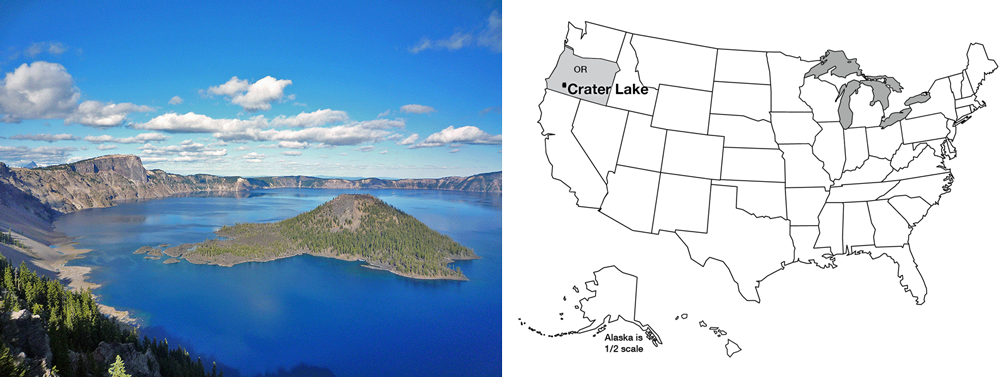
Crater Lake, at 1932 feet (about 600 m) deep, is the deepest and probably the cleanest lake in the United States, and surely among the most beautiful. Crater Lake sits in a great volcanic crater or caldera, 5 miles (8 km) across, formed when Mt. Mazama experienced a cataclysmic eruption about 6600 years ago. That massive eruption laid down ash that is 200-300 feet thick (almost 100 m) on the flanks of the volcano; the ash forms a recognizable layer hundreds of miles away in Yellowstone, and has been identified in Greenland ice cores.
The peak of the volcano had risen more than a mile above its mile-high base on the highlands of southwestern Oregon, but the great eruption removed about 4000 feet (1200 m) from the mountain’s height. About 16 cubic miles (40 cubic km) of rock were blown away. Glaciers had flowed down from the mountain peak; today, the glacial valleys can be followed upward until they disappear at the caldera rim. Although 50 feet (15 m) of snow falls in a typical year now, melting in the summer is sufficient to remove all this snow, and no glaciers exist. A tongue-in-cheek Christmas celebration on Aug. 25 substitutes for the snowbound December event.
After the great eruption, lava flows began building Wizard Island. If the water were removed from the lake, you could see that Wizard Island is roughly 0.5 mile (0.8 km) high. No permanent streams feed into the lake; the great rainfall and snowfall in the crater are balanced by evaporation, and by seepage through the rocks and eventually out the sides of the volcano as springs. With no streams supplying sediment, the lake is exceptionally clear and clean. Aquatic moss receives enough sunlight to grow 425 feet (130 m) below the water surface. When trout were stocked in the lake, freshwater shrimp were stocked first because otherwise biologists feared that the trout would have nothing to eat.
We will discuss volcanoes soon. For now, note that Crater Lake sits atop one of a string of volcanic peaks: Lassen Volcanic National Park and Mt. Rainier National Park preserve other peaks in the Cascades range. Mt. St. Helens, Glacier Peak, and several others are protected federally. These peaks line up in a row, called a volcanic arc, parallel to the coast. A similar arc sits along much of Central America, and forms the Andes of South America. And similar arcs also occur as island chains—the Aleutians, Japan, and others. In fact, the Pacific Ocean is almost entirely encircled by such volcanic arcs, forming the “Ring of Fire”.
Ring of Fire
Sitting offshore of the Ring of Fire is a ring of trenches, which include the greatest depths of the ocean. The trenches parallel the arcs. Some trenches, which sit near continents, are nearly filled with sediments dumped off the continents, but other trenches are almost free of sediment and so have very deep water, to almost 7 miles (11 km) deep. (Figuring out depths often is complicated by sediment. The surface of Death Valley sits more than two miles lower than the adjacent peaks of the Sierra Nevada. But below the salt flats of Death Valley there are sediments as much as three miles thick, materials that were eroded off the tops of the peaks, so the valley has dropped by much more than three miles relative to the peaks.)
The trenches and volcanoes that ring the Pacific are clues to help solve a problem that might have been bothering you from last time. If sea floor is made at spreading ridges and then moves away, where does it go? The earth is not getting bigger. (Well, meteorites are adding a tiny, tiny bit, but not nearly enough to account for sea-floor spreading.) So, the sea floor must be disappearing somewhere. The oldest sea floor we know of is only about 160 million years old, but the continents contain rocks as old as almost 4 billion years, suggesting that the sea floor is being consumed before it gets very old. (Remember, before the class ends, we’ll discuss how geologists date rocks.) (And remember that when a geologist dates a rock, it involves physics or chemistry but not dinner or a movie.)
Now, a few more clues. Sea floor is made of basalt. This is just the kind of rock that would be made if you melted a little bit of the deep, convecting rocks of the Earth’s mantle, and let that melt float up to the surface and “freeze” (cool until it solidifies). If you take basalt, a little ocean sediment, and some ocean water, and heat them enough to cause a little melting, let that melt come to the surface and freeze, you obtain a rock called andesite with a little more silica and a little less iron and magnesium than basalt, lighter in color and lower in density than basalt. Interestingly, the dominant rock in the walls of Crater Lake, and in the other Cascades and Ring-of-Fire volcanoes, is andesite (named after the Andes, which are part of the Ring of Fire).
If sea floor were plunging under the continents and melting to make andesite, you might expect that occasionally the downgoing rocks would get stuck and then break free, making earthquakes. Indeed, a three-dimensional map of earthquakes shows that shallow ones occur near the trenches, and the quakes are progressively deeper inland beneath the volcanic arcs. The great 1964 Alaska earthquake was such an earthquake, which happened where rocks of the Pacific Ocean floor plunge to the north under coastal Alaska and the Aleutian chain. The earthquakes there are shallow to the south and deepen to the north, along the downgoing rocks. The disastrous 2011 Tohoku earthquake in Japan was of the same type.
Careful work on the speed of earthquake waves, which is affected by the temperature of rocks, even provides a picture of cold slabs going down into the hotter mantle. As these downgoing slabs of rock are heated, with their water and sediment, a little melt is produced. (Interestingly, wet rocks melt at a lower temperature than do dry rocks, just as adding a little water to flour and yeast speeds cooking in the oven.) When the melt rises to the surface and cools, andesite forms, such as is seen around Crater Lake, in the Andes, or in the Aleutian volcanoes.
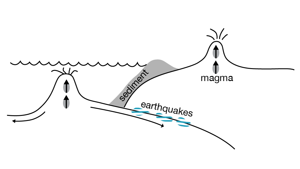
So, sea floor is made at the spreading ridges. It is hot and low-density initially, but cools and contracts as it gets older and loses heat to the colder ocean water. When sea floor becomes cold and dense enough, it can sink back into the mantle, and we call the place where it sinks a “subduction zone”. The sinking sea-floor slab drags along a little sediment and water, warms up and melts a little of the slab and some of the sediment, and feeds the volcanic arcs. Old sea floor is going down around much of the Pacific Ocean, and in a few other places such as beneath the Caribbean and beneath portions of the Alps. Wherever this happens, andesitic volcanic arcs form (see Figure 1).
Figure 1. Here the cold, dense seafloor sinks beneath into the mantle, creating a subduction zone. Credit: R.B. Alley
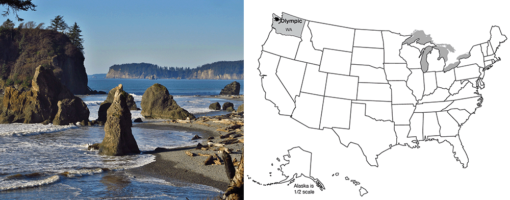
The Olympic Peninsula juts out into the Pacific Ocean, separated from Seattle by Puget Sound. Moisture-laden winds off the Pacific dump more rain and snow on the Olympic than anywhere else in the lower-48 United States. Great old-growth forest trees—Sitka spruce, Douglas fir, etc.—tower up to 300 feet (almost 100 m) above the forest duff, where butterflies flit past crystalline streams and cascading waterfalls. Along the coast, sea lions bask on offshore stacks, while urchins and starfish populate tidal pools. On the “high peaks,” numerous glaciers form and flow downhill. More snow accumulates than melts above about 6000 feet (2000 m). On most mountains, you have to go much higher to find summertime snow, but the huge winter snowfall on the Olympic allows the peaks to be snow-clad year-round despite rising less than 8000 feet (about 2500 m) above sea level.
Olympic National Park is a bit unusual in that it was established as much for biological reasons as for geological—to protect the Roosevelt elk that live on the peninsula. (The elk, named after Theodore Roosevelt, were critical in obtaining national monument status, which was signed by President Theodore Roosevelt. Later, the upgrade to national park status was signed by President F.D. Roosevelt. The Roosevelt elk is the largest of the elk subspecies in the country. Some consideration was given to naming the park Elk National Park before Olympic was chosen.)
The geologic story of the Olympic is somewhat shorter and less dramatic than for most of the national parks. The rocks of the Olympic are almost all young–less than 40 million years. (Again, please bear with us—we will justify these numbers before the course ends!) Before that, the coastline must have been farther to the east, perhaps in North Cascades National Park, and before that even farther east.
The Olympic Grocery
You’re standing at the grocery-store checkout. You put a bag of potato chips on the conveyor, and off they go, followed by a case of Pepsi, three loaves of bread, a watermelon, a box of Ho-Hos, and a sack of potatoes. Then, you realize that there is no bagger working, and that everything is piled up at the end, in a BIG mess. That mess is a good model for the Olympic Peninsula, and the whole coast from there up to Alaska.
The rocks of the Olympic Peninsula are a mixture of sea-floor basalts and of the sorts of sediments that accumulate today off the coast and fill the trench there. Rivers draining the peninsula, and much of the west coast, carry great loads of sediment down to the ocean. Much of that sediment piles onto sea floor that is slowly moving beneath the continent, a conveyor belt that tries to pull the sediment down to melt and be erupted. Most of those sediments are “scraped off” on the way down, just as at the grocery store. The Olympic Peninsula is the offscrapings. Most of the rocks have been bent and twisted from the attempt to shove them under the continent (think of the potato chips after the Pepsi hits them!). Some of the Olympic rocks have been heated a good bit—the conveyor belt took them down a ways, but they then were squeezed back out.
Our emerging picture of plate tectonics is that the earth is heated inside, softening the deep rocks of the asthenosphere enough that they can move in great, slow convection currents that transfer heat from deep in the earth to near the surface. Heat is conducted through the upper rocks, or is erupted through them by volcanoes, and eventually is lost to space. But, the upper rocks in most places are cold enough that they tend to break rather than flow—they are brittle. These brittle rocks form the lithosphere, which includes the crust and the uppermost mantle. The rocks of the crust in continents are rich in silica (often like andesite in composition), making them light in color and low in density, so that they float on the deeper rocks and are rafted around on them by the moving convection currents. The sea floor rocks in the crust fall between the continents and the mantle in composition, and typically are basalt. The sea-floor rocks are usually intermediate between continents and mantle in density as well, but if the sea-floor rocks are cold enough, they will be slightly denser than hot mantle. Then, the sea-floor lithosphere consisting of the sea-floor crust plus a little attached mantle will sink into the asthenosphere of the deeper mantle.
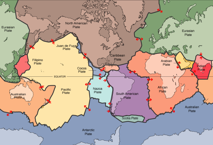
The lithosphere is broken into a few big rafts, called plates—eight big ones plus some smaller ones, depending a little on how you define “big” and “small”—that float around on the convection cells below. Plate boundaries include spreading ridges where the plates move apart (remember Death Valley and the mid-ocean ridges), and subduction zones where the plates come together and one side sinks under the other. You might imagine that if plates can come together or pull apart, they must be able to slide past each other as well, which is what happens at the San Andreas Fault in California (we met it when we were discussing earthquakes); such slide-past boundaries are often called transform boundaries or transform faults (see Figure 1). You might worry that sometime, two continents would run together; we’ll meet that soon when we visit the Great Smoky Mountains.
Figure 1. A map of the world with boundaries of tectonic plates highlighted. Plate boundaries include “pull-apart” spreading ridges, “push-together” subduction and obduction zones, and “slide-past” transform faults. Credit: R.B. Alley
The lithosphere and asthenosphere are solids, but a little melted rock may occur in the asthenosphere, and leak out where plates are pulled apart, feeding basaltic volcanoes. And the water taken down subduction zones can stimulate a little melting, feeding andesitic volcanoes that line up in arcs above the downgoing slabs of the subduction zones; examples of these volcanic arcs include the Cascades, Aleutians and Andes. Continents are a collection of scum from melting of the mantle, too low in density to sink back into the mantle. Continents grow as the conveyor belt from the mid-ocean ridge to the subduction zone brings in sediments and islands and what-not, or when andesitic volcanoes are erupted on continents, or when andesitic volcanoes form an arc offshore that then collides with a continent (sometimes the site of subduction moves, and the volcanoes find themselves on the conveyor belt, or they hit a different continent). Because much of the sediment comes from the continents themselves, the growth of continents is not fast—material eroded from the continents falls on the conveyor and is added back at Olympic or erupted back at Crater Lake.
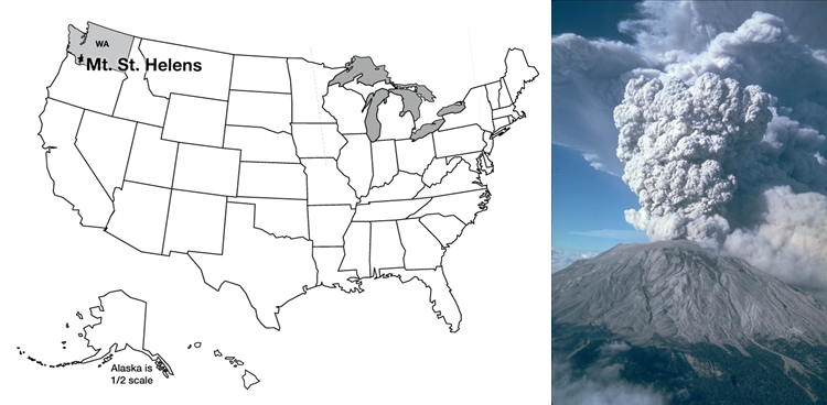
Mt. St. Helens & Volcanic Hazards; More to Worry About
Mt. St. Helens, in southwestern Washington, was in some ways the queen of the Cascades Range. Beautifully symmetric, snow-capped, it had been called the Fujiyama of the Pacific Northwest. Scores of people flocked to St. Helens’ flanks to hike, camp, ski, and generally enjoy the environment. And all that changed in 1980.
Mt. St. Helens has also been the most active of the Cascades volcanoes over the most recent centuries. In early 1980, the volcano clearly was “waking up”. Earthquakes shook it almost continuously, including special “harmonic tremors”, similar to those sometimes caused by fluid flow in pipes, which showed that liquid rock was moving up from below. Small eruptions occurred, and hot springs and fumaroles (steam or gas vents) became increasingly active. The north side of the mountain was bulging, blowing up like a balloon as the magma moved into it. Scientists were scrambling to study the volcano, and predict its course. They recommended evacuation for safety, and most people (but not all, including some scientists) were moved out of the way. Penn State professor Barry Voight warned that the huge bulge on the north side of the volcano would fail, unleashing a giant landslide and a devastating eruption.
On the morning of May 18, 1980, Professor Voight’s prediction came frighteningly, awesomely true. The bulge failed. A large earthquake either caused, or was caused by, failure of the north side of the mountain in a giant landslide. Like pulling the cap off a hot, well-shaken soda bottle, the liquid beneath flashed into froth, driving an eruption 12 miles (20 km) high. A shock wave knocked over full-grown trees in an area 20 x 10 miles (32 x 16 km). The landslide eventually poured more than 100 million cubic yards of rock material down the Toutle and Cowlitz Rivers, raising the floor of the North Fork of the Toutle as much as 600 feet (200 m), and sweeping roads and houses downstream, with the debris reaching and clogging the shipping channels of the Columbia River. The Toutle floor now sat higher than the smaller streams that fed it, and lakes began to form; only quick work by the Army Corps of Engineers prevented those lakes from overtopping the mud damming them, cutting quickly down through it and releasing further floods.
All told, the Corps of Engineers spent $250 million clearing shipping channels and doing other critical work. Approximately 60 people were killed in the blast and landslide; some were buried under hundreds of feet of steaming mud and their bodies were never recovered.
President Jimmy Carter scowled at the disaster from a helicopter. Disaster planners pontificated. And in the shadows of the other Cascades volcanoes, people continued building houses in regions of known volcanic hazard.
The Mt. St. Helens Volcanic Memorial today has little in common with conditions pre-1980. The center of the volcano was more than 1/2 mile (nearly 1 km) lower after the eruption than before, with the missing rock spread over the surrounding countryside, forming a visible layer as far as 900 miles (1500 km) away. (Professor Alley and his wife Cindy were driving in Alberta, Canada during the summer of 1980, on a great, seven-week, see-the-national-parks-in-a-Chevette-with-a-tent honeymoon. A secondary eruption of Mt. St. Helens put enough ash in the air to halt traffic because of reduced visibility, hundreds of miles from the volcano.) Many of the trees knocked over by the blast still lie there—hundred-foot-long toothpicks pointing in the direction of the searing winds of the blast. Among these dead trees, however, salmonberry and fireweed and young firs are pushing skyward, elk are grazing, and coyotes search for rodents. In some places, salvage-logging of the downed trees was allowed. In some of those places, it appears that erosion has run amok, large gullies have developed, and the return of vegetation has been greatly slowed. In the crater of the volcano, a new lava dome is forming, squeezing slowly upwards like toothpaste from a very hot tube, and amazingly, a glacier sits behind it, fed by the great snowfall and the avalanches down into the crater. At night, the dome glows dull red. (It may seem weird that we focus on an event from before most of you were born, from 1980, when larger eruptions have happened more recently. But, St. Helens is the largest recent eruption in the lower-48 of the US, the easiest eruption site to get to and observe, and it really is awesome. The elder Alley daughter, Janet, was a ranger there one summer, and recommends that you take in Ape Cave if you visit, but the real goal is to see just how immense the eruption’s effects really were.)
Types of Volcanoes
Volcanoes occur where melted rock rises to the Earth’s surface. Almost all volcanoes are associated with one of three settings—pull-apart margins (spreading ridges), push-together subduction zones, and hot spots. We’ve already met the volcanoes at spreading ridges, where low-silica basalt is erupted, and those producing higher-silica andesite at subduction zones.
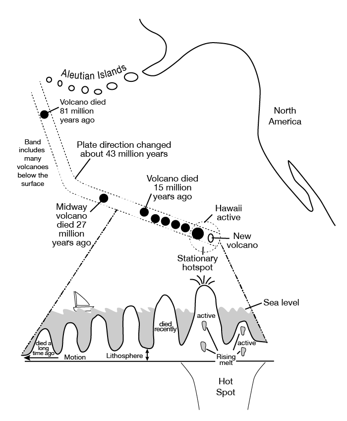
Hot spots are creatures of another type in the zoo of Earth’s features, and especially interesting creatures at that. Deep in the warm, soft, convecting mantle of the planet, in some places a rising tower of hot rock forms and then lasts for quite a while. Some of these rising towers may come all the way from the base of the mantle where it meets the core; others may start shallower. (To see something that looks vaguely like the formation of such a hot spot, go back and view again the “lava lamp” film of Dr. Anandakrishnan in the introductory material to this unit.)
As the lithosphere drifts overhead, the hot spot may “punch through” to make a volcano. Then as the lithosphere carries that volcano away, the hot spot punches through a new place to make a new volcano. Rising melt behaves a little bit like people driving cars, who use one road or the other but not the lawn in-between; hot spots often make a string of separate volcanoes rather than a continuous line or ridge, by coming up through one hole in the lithosphere for a while and then switching to a different one. Hot spots bring melt from deep in the mantle, and so normally make basaltic volcanoes (it takes fairly subtle and sophisticated chemistry to tell the difference between hot-spot basalt and sea-floor basalt from spreading ridges). However, where a hot spot pokes through a continent rather than through sea floor, silica from the continental rocks may mix with the melt to increase its silica content, as at Yellowstone.
The Hawaiian hot spot has produced a string of volcanoes, shown here, as the Pacific sea floor has moved over the rising hot rock of the hot spot.
When a new hot-spot first rises from below, the top must push through the mantle and crust, and the resistance of the stuff in the way of the rising column causes its top to spread out like the head of a thunderhead, or of a mushroom cloud from an atomic bomb, or of a blob in a lava lamp, and for the same reasons. When that wide head reaches the surface, immense lava flows can be produced that spread across state-sized areas and bury them hundreds of feet deep. Much of central and eastern Washington and Oregon is buried by the “flood basalts” from the head of the Yellowstone hotspot. As the continent has moved across the hot spot after it reached the surface, a string of volcanoes erupted including Craters of the Moon National Monument in Idaho. The hot spot now fuels Yellowstone (which is why it is called the Yellowstone hot spot…a lot of this stuff isn’t that difficult!).
The flood basalts from the Hawaiian hot spot have been subducted beneath the Aleutians, but the string of volcanoes that has formed since from the hot spot can be traced from the Aleutians south all the way to the volcanically active big island of Hawaii. A new volcano, Loihi Seamount, is growing undersea just off Hawaii as the big island slowly drifts away, and Loihi will someday (not in our lifetimes!) be the new, volcanically active “big island” while the volcanoes of the current big island die and the island slowly erodes away.
So, melt can leak up from below to feed volcanoes at spreading ridges, at hot spots, and above subduction zones. But very different volcanoes develop: sea floor from spreading ridges; flood basalts and then wide, not-very-steep Hawaii-shaped volcanoes from hot spots; and, steep Mt. St. Helens-type volcanoes above subduction zones. The type of volcano that develops at a place depends on a host of factors: temperature, composition, supply of melt, duration of supply, and several others. We will focus on two: composition (how much silica) and volatile content (mostly how much water, although carbon dioxide, hydrogen sulfide, and other compounds that are gaseous under earth-surface conditions may be present and classified with volatiles). Silicon and oxygen get together in melt to form the material we call silica. Left to itself, each silicon atom will be surrounded by four oxygen atoms, which form a tetrahedron (a little pyramid). But, give them a little time, and the tetrahedra will start sticking together, or polymerizing, into chains and sheets and bigger clumps, with some oxygens serving in more than one tetrahedron. If these lumps get big enough, they are minerals and the melt has solidified.
When the lumps are present but not too big, the melt is like lumpy oatmeal—it doesn’t flow very well. There are three ways to get rid of the lumps: make the melt really hot; fill the melt with iron, magnesium and other elements that interfere with the tetrahedra polymerizing; or, fill the melt with volatiles that interfere with the tetrahedra polymerizing. When polymerization is low, the melt flows easily. Lava comes out of the volcano quietly, without making big explosions, and flows easily and far from the mouth of the volcano. In extreme cases, flows may be nearly horizontal and cover much of a state, as in the flood basalts. If the melt spreads almost as easily as flood basalts, the lava will have very slight slopes of only a few degrees, forming shield volcanoes (they look like a warrior’s shield lying on its side) such as Hawaii. Hawaiian lavas and flood basalts flow easily because they are hot and are high in iron and magnesium.
When volatiles remove the lumps, a different situation develops. This is because the volatiles will only stay in the melt under high pressure. Just as a bottling company can force CO2 into the water of a soft drink under high pressure, but the CO2 escapes as the pressure falls when you open the can, the water and CO2 and other volatiles stay in the melt under high pressure down in the Earth but escape when the melt gets close to the surface.
Silica-rich melts usually form with many volatiles. Remember that in subduction zones, wet sediment dragged down the trench releases water (and carbon dioxide and others) that promote melting. When the melt (called magma when it is in the Earth and lava when it reaches the surface) nears the surface, the lower pressure allows the volatiles to bubble off and escape into hot springs, geysers, etc. (Note that most of the fluids that come out of such hot springs are rainwater that has circulated down into the earth, but some of the fluids may be “juvenile” waters from the magma below.) Silica-rich, relatively cool lava that has lost its volatiles flows only with great difficulty. It may emerge from the volcano and flow a little ways as a very thick, slow-moving, steep flow. It may not even flow, but simply form a dome directly over the volcanic vent. And, it may “plug the system” when it solidifies. Then the stage may be set for a big explosion.
The next melt that rises in the volcano cannot follow the same path, because hardened lava above prevents escape. The gases are trapped, and pressure builds up. The volcano is like a hot, shaken pop bottle. If the top is removed, either by an opener (say, a landslide as in the case of Mt. St. Helens, or a crack opened by an earthquake) or just because the pressure becomes great enough to blow the top off, the sudden release allows the soda, or the magma, to come foaming out. A good champagne may fountain to many times the bottle’s height, and blast the cork across the room. A powerful volcano may blast ash higher than jet flight paths. The melt really does get foamy, and that foam hardens into little glass shards. The ash layer deposited by Mt. St. Helens, which stopped drivers hundreds of miles away, was mostly of such little glass shards, although torn-up bits of the former volcano were also included.
The andesitic volcanoes of the Ring of Fire are typically stratovolcanoes, formed of alternating layers of thick lava flows and of pyroclastics—things thrown through the air by the volcano. The steepness comes from the flows, which cannot get far from the vent. Some of the andesitic volcanoes, including the rebuilding Mt. St. Helens, include plug-dome elements, the oozing lava staying right above the vent.
So, the major volcanoes for our purposes are the quiet, basaltic shield volcanoes of hot spots, the quiet basaltic rift volcanoes of spreading ridges, and the steep, scenic, explosive, andesitic volcanoes of the Ring of Fire. Other types exist, notably cinder cones thrown up by typically minor eruptions tossing pyroclastics short distances. Also, hot spots or rifts trying to poke through continental rather than oceanic crust may produce explosive silica-rich volcanoes. But if you understand shields and stratovolcanoes, you will be a long way toward understanding volcanism.
Volcanic Hazards and Prediction
People who live near volcanoes should be worried about them. Volcanoes can do much damage. The volcanic-triggered landslide that buried Armero, Colombia in 1985, and the eruption of Mt. Pelee on the island of Martinique in the Caribbean in 1902, each killed about 30,000 people. Other volcanic disasters bring the human death toll to perhaps 200,000 over the last few centuries. Compared to war, disease, or even automobile accidents, this is not a terribly high toll; however, the 200,000 people directly involved almost certainly would have appreciated enough warning to get out of harm’s way. One of the goals of modern geology is to predict volcanic hazards and to save lives and property by doing so.
There are many hazards to worry about. These include:
Pyroclastic flows. Often, a volcano will produce a dense mixture of ash and hot gases (up to 1500oF or 800oC, and including poisons such as hydrogen sulfide). This potentially deadly mix is either forced away from the volcano (the lateral blast released by the landslide on Mt. St. Helens) or forced upward to then collapse and flow under gravity, at speeds up to hundreds of miles (hundreds of km) per hour. The deaths on Martinique were caused by such a “glowing cloud” (nuee ardente in French, where the only survivor in the whole city of St. Pierre was a lone man locked in a heavily built prison.)
Pyroclastics. If the heat and gases don’t get you, the rocks might. People have been killed by rocks up to car-sized or bigger, called bombs, that were thrown from volcanoes. Having a car-sized rock fall on your head from a great height is not recommended. Even fine-grained ash deposits may bury and kill nearby crops. Jet aircraft are endangered by flying into ash at high speeds. From 1980-1995, ash caused an estimated $200 million in damage to the 80 aircraft that flew into eruption clouds, mostly over the Pacific. Of those, seven lost engine power and came close to crashing. Improved monitoring of eruption clouds, to provide warnings and steer the airplanes into safer air, has greatly reduced damages since then. However, to avoid crashes from the 2010 eruption of Eyjafjallajökull in Iceland, literally millions of passengers were stranded in Europe and elsewhere as flights were suspended over weeks.
Poisonous gases. Sometimes, a volcano will smother or poison victims without burning them up. Pompeii and Herculaneum, the cities entombed by the eruption of Vesuvius in the year 79, have proven to be archaeological treasures, but certainly would be considered tragedies by the many people killed there and by their relatives. The people apparently were killed before they were buried, and they were not “fried” by intense heat; they probably were killed by poisonous gases and then buried by falling ash. Lake Nyos in Cameroon rests in a volcanic crater. Volcanic CO2 feeds into the bottom of the lake, but the lake typically remains stratified and does not mix. The CO2 thus builds up in the deep waters. In 1986, the lake overturned, perhaps because a landslide from the crater wall temporarily mixed the water at one end. The escaping CO2 made a great fountain, filled the crater, and then flowed down outside the crater, killing about 1700 people through some combination of suffocation and poisoning. The lake now is re-stratified and building up CO2 again; schemes to vent the CO2 safely through a huge pipe are working, but additional work may be needed to prevent a repetition.
Landslides and mudflows. These are less dramatic, but more dangerous cumulatively, than the explosive events. Most of the andesitic volcanoes are steep, and many are capped by very large glaciers. Mt. Rainier, for example, has 25 times as much glacier ice as Mt. St. Helens had, ready to melt and trigger mudflows after even a minor eruption. The tragedy at Armero arose from a minor eruption that triggered a big landslide. It is worth noting that Armero was built on a known, older debris-flow deposit.
Tsunamis. A large undersea eruption may move a lot of water. This water movement may form into a tsunami, a long, low wave that moves very rapidly. When a tsunami nears a shore, the water “piles up” into a short, steep wave that may be 100 feet high. Such waves, which also can be caused by landslides or earthquakes, may affect coasts hundreds of miles (or kilometers) from the source. The largest eruption of historical times, that of Krakatau in Indonesia in 1883, killed thousands of people on neighboring islands in this way. The great Tohoku earthquake of 2011 in Japan made a tsunami that was over 130 feet high (40 m) at its worst, where it came ashore where people lived. We’ll look more at tsunamis soon.
Climate change. A large volcanic eruption puts a lot of sulfur gases into the stratosphere, together with ash and other materials. The sulfur eventually forms sulfuric-acid droplets, which typically remain aloft for one to a few years before falling out across much or all of the planet. While they are aloft, the sulfuric-acid droplets block some of the sunlight, cooling the planet a little. This can produce killing frosts during normal growing seasons, leading to widespread starvation in sensitive regions. The Tambora eruption of 1815 is associated with the starvation “year without a summer” of 1816. Ice cores from Greenland, Antarctica and elsewhere record volcanic fallout (the ash and sulfuric acid are preserved in the ice) and the temperature (from certain indicators including the isotopic composition of the ice), and show that big eruptions typically are accompanied by a cooling of a good chunk of a degree for a year or two, with more cooling in some places and seasons, and less in others. This isn’t a huge change, but when one killing frost can cause starvation, it may be too much. If many volcanic eruptions occurred in a short period of time, it might produce major climate changes; however, volcanism doesn’t seem to get organized—there is no way for a volcano in Alaska to tell a volcano in Indonesia that it is time to erupt. (Volcanoes also release carbon dioxide, which tends to warm the climate, as we will see later in the course. However, not a lot of carbon dioxide comes out in one volcanic eruption. If all the world’s volcanoes started erupting a lot faster, maybe twice as fast as normal, enough carbon dioxide would be released in “only” a few hundred thousand years to start warming the world notably. Over really short time scales of years to centuries, more volcanism would cause more cool years, because the sun-blocking effect would be much bigger than the warming-from-carbon-dioxide effect. If you turned up volcanoes, you would get first cooling and then warming.)
Predicting Eruptions
So, we wish to predict when and where volcanoes will endanger people. Various things can be done. For problems such as climate change, the best we can do is to know that every few years or decades some region is likely to experience difficulties with crop production because of eruptions. The solutions are either to maintain a little excess food to feed those endangered people, or to ignore them and figure that some will starve to death. (Many other climate changes, including droughts, give us the same choice. Despite the apparent silliness—either we stockpile food and figure out how to distribute it to the needy, or we let people starve to death—it is surprising how often starving to death is the outcome.)
For tsunamis, an operational warning system now exists around the Pacific and in some other places. If a tsunami is detected, or if seismographs detect the shaking caused by a large earthquake, landslide, or volcanic eruption, warnings are relayed to coastal regions likely to be affected, in time to allow evacuation. Such a system is being assembled for the Indian Ocean following the tragic 2004 earthquake-generated tsunami that killed approximately 250,000 people.
One way to avoid volcanic hazards is to stay out of harm’s way. Geologists can map regions where large pyroclastic chunks have fallen, or where landslides have occurred, with great confidence. Using carbon dating of logs caught in debris flows, or tree-ring dating of those growing on landslides (just hang on; explanation of such things will come later), we can determine the recurrence interval—how often do such disasters happen? Today, whole subdivisions are being built around Mt. Rainier National Park in the growing Seattle-Tacoma region that have a danger of destruction by landslide many, many times higher than their danger of destruction by fire. Roughly 200,000 people work, and more than 100,000 people live, on debris-flow deposits less than 10,000 years old, with more people coming. The homeowners will all carry fire insurance, but few if any are insured against the volcano; presumably, if they survive the next volcanic disaster, these people are counting on disaster aid from the rest of the country to bail them out.
(Much argument is attached to sending disaster aid for predictable events even if they are not very common. Should those who wish to live in beautiful but risky areas carry insurance to pay for their gambles? Increasingly, planners are saying “yes,” and much effort is being devoted to quantifying the hazards so that insurance rates can be set wisely. This applies to such things as hurricanes along coasts, earthquakes along faults, and floods along rivers. Geologists have an important role to play in learning hazards and thus setting rates.)
With sufficient care, volcanic eruptions can be predicted with some confidence. Volcanoes usually give off many signals before an eruption: the ground swells as magma moves up; the moving magma and the swelling ground create earthquakes and especially the distinctive harmonic tremors of fluid flowing in a pipe; small eruptions occur; gaseous emissions increase as the magma nears the surface and then cease if the system becomes plugged and builds up pressure for an explosion. A monitoring program of seismographs to detect earthquakes, repeat surveying of laser reflectors set on the mountain to watch for deformation patterns, gas sampling, and perhaps photographic or other sensors to watch for landslides, can track a volcano’s behavior and allow timely warning. Monitoring of ground shape from space can even see the changes in volcanoes as magma moves under them. The eruption of Mt. St. Helens was predicted well enough to save hundreds of people including the residents of a YMCA camp. The eruption of Mt. Pinatubo in the Philippines in 1991, which heavily damaged the U.S. military bases there, was predicted accurately, allowing timely evacuation and saving tens or hundreds of thousands of lives of residents and military personnel.
The burden of predicting eruptions is very high. Imagine telling an Air Force general to abandon his or her assigned duty post, spend a few hundred thousand dollars to move tens of thousands of people, and then having nothing happen—the general, and all of those people, would be very unhappy. Imagine instead deciding to wait another day to be sure, and having all of those people (possibly including you) killed. Important as this is, predicting disasters is not for the faint of heart.
The Mt. St. Helen’s eruption was a small one compared to many others. Each of the major eruptions of Yellowstone moved about 1000 times more material than Mt. St. Helens did, and Yellowstone’s eruptions were not the largest known. Small eruptions are more common than large ones. But, eruptions ten times as big as Mt. St. Helens are perhaps five times as rare, but not ten times as rare. This means that, as for earthquakes, most of the “work” done by volcanoes is achieved by the few big ones, not the many little ones.
Key Takeaways for Volcanism
Subuction
Sea floor is basalt
Although sea floor is generally less dense than mantle, very old, cold sea floor can be dense enough to sink into hot mantle.
Sea floor is lost where it sinks back into the mantle at Subduction Zones. All sorts of things happen there:
Moving rocks stick, then slip, giving earthquakes.
Mud and rocks and even islands are scraped off the downgoing slab, piling up on coastlines
Some mud and water are carried even farther down; the water lowers the melting point of the rocks
A little melt is generated, rises, and feeds volcanoes (Crater Lake, Mt. St. Helens, etc.) that form arcs at continent edges or offshore.
This melt is richer in silica and poorer in iron than the basalt it comes from, and is called andesite
Lithosphere broken in few big plates and many little ones; most “action” is at plate edges.
Plates come together at subduction zones, where cold sea floor dense enough to sink into hot mantle, where scraped-off materials pile up to make edges of continents (Olympic, etc.), and where water and sediment taken down lower melting point of rock, feeding silica-rich (andesitic) volcanoes.
Introducing Volcanoes
Towers of rising rock from very deep (often core-mantle boundary) feed “hot spots.”
Plates drift over the top, and hot spots occasionally punch through to make lines of volcanoes, which often are oceanic islands (seamounts).
Hawaii is the classic example.
Yellowstone also a hot spot
Volcano Characteristics
In melted rock, silicon and oxygen make SiO4 tetrahedra that try to polymerize (stick together in chains, sheets, etc.) to make lumps.
Can break up lumps with great heat and much iron (in basalt); makes lavas that flow easily and don’t explode
Can break up lumps with volatiles (water, CO2 , etc.), but when these escape near surface, lava won’t flow easily and plugs system, so next time trapped volatiles explode; form steep stratovolcano with alternating flows and pyroclastics (blown-up bits) from explosions.
Volcanic Hazards
Pyroclastic flows, deadly hot, fast rock-gas mixes.
Pyroclastics, volcanic pieces in size range from ash to blocks of rock
Poison gases, that kill many very quickly.
Landslides and mudflows, that bury whole cities.
Tsunamis, giant waves that devastate coasts.
Climate change, especially cooling from particles blocking the sun and frosting crops.
Predicting Volcanoes
Easy to figure out where they are likely.
Often, but not always, possible to figure out that eruption will happen in next days or hours.