Chapter 2 – Tectonics and Earthquakes
Earthquakes
Learning Objectives
Welcome to Chapter 2. At the end of this chapter you will be able to:
- Describe the major layers of Earth and their physical properties
- Explain how seismic waves are used to define Earth’s interior
- Differentiate between radiation, conduction, and convection and their roles in mountain making and earthquakes
- Demonstrate an understanding of Elastic Rebound Theory
- Differentiate between P and S seismic waves and their behaviors through Earth’s interior
- Demonstrate an understanding of the Richter scale and earthquake intensity
- Compare and contrast the characteristics of plate boundary types and their importance in the formation of land forms, the ocean floor, and spreading of the Basin and Range
- Explain the relationship between Death Valley and the Gulf of California
Death Valley is Growing Wider: Death Valley and Sea-Floor Spreading
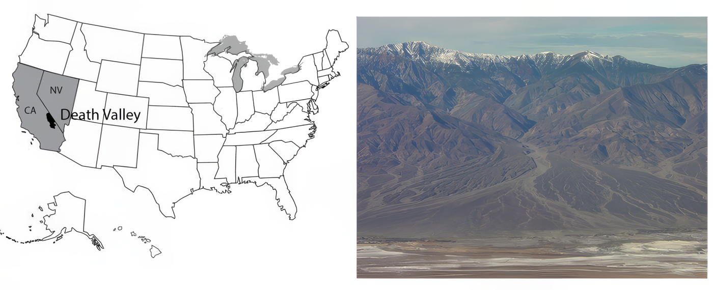
Death Valley National Park of California and adjacent Nevada sits as deep as 282 feet below sea level near Badwater, the lowest land in the western hemisphere. Yet, Telescope Peak in the Panamint Range, 11,049 feet high, is in the park less than 20 miles west of Badwater, and Mt. Whitney, at 14,494 feet the highest peak in the continental United States, is only about 80 miles away.
Death Valley is the hottest, driest place in the United States. On July 10, 1913, the temperature reached 134oF (57oC), and 125oF is common. All of the rainfall (about 2 inches or 5 cm per year) evaporates quickly.
Occasionally, water will sit on mud flats for a while (especially in the colder winter) before evaporating to leave salt deposits. Sometimes in winter, the water freezes on top, and strong winds blow the ice, dragging rocks that are frozen in it. The tracks of such rocks, at the Devil’s Race Track, long puzzled people before the answer was discovered. (And you’ll still find people who argue about the tracks and rocks out on the flat surface—no one has ever watched the rocks when they were moving!) During the ice age, more rain and cooler temperatures than today caused the valley to fill with water, forming Lake Manly, which was about 90 miles (150 km) long and almost 600 feet (200 m) deep at its deepest.
Salts left on mud flats by evaporating waters often contain boron, a rare element that has leached from volcanic rocks nearby and been carried into the valley by streams. Boron is used in soaps, water softeners, pottery glazes, and other things. Mining of the boron-bearing borax salts began in the early 1880s, and they were hauled out by the famous 20-mule teams. Mining was allowed to continue in the park after it was established (as a national monument in 1933, and a national park in 1994), but is being phased out. Copper, gold, silver, lead, and talc have been mined in or near the park.
Pull-Apart Faults
The great depth of Death Valley was not carved by a river or glacier or the wind and is not from a cave like Mammoth Cave collapsing. Instead, as shown in the diagram below, labeled Pull-apart fault at Death Valley (which is more-or-less what you would see if you could take a slice across the valley from the air at the top down into the Earth at the bottom), Death Valley has been dropped along faults as the region has been pulled apart. Similar downdropped and upraised blocks extend across much of Utah, Nevada, and neighboring areas, forming the Basin and Range region. A little bit of such faulting even extends up into Wyoming, and the great front of the Teton Range is geologically a close cousin to the west side of Death Valley.
The geologic evidence of faulting is clear—layers of rock and even recent stream deposits are offset across the faults, as you’ll see in a VTrip at the end of this unit. The faulting occurs in fits and starts rather than smoothly, producing earthquakes. The Basin and Range region remain active in producing earthquakes. (More about earthquakes is coming soon.)
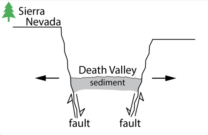
Because of the way that the faults are angled, the dropping of blocks requires that the region is getting wider! (Look again at the diagram to the right labeled Pull-apart fault at Death Valley.) It has recently become possible to measure this widening using GPS or very-long-baseline-interferometry techniques. The widening is not fast—maybe an inch or two (a few centimeters) per year across the whole Basin and Range—but the widening is occurring.
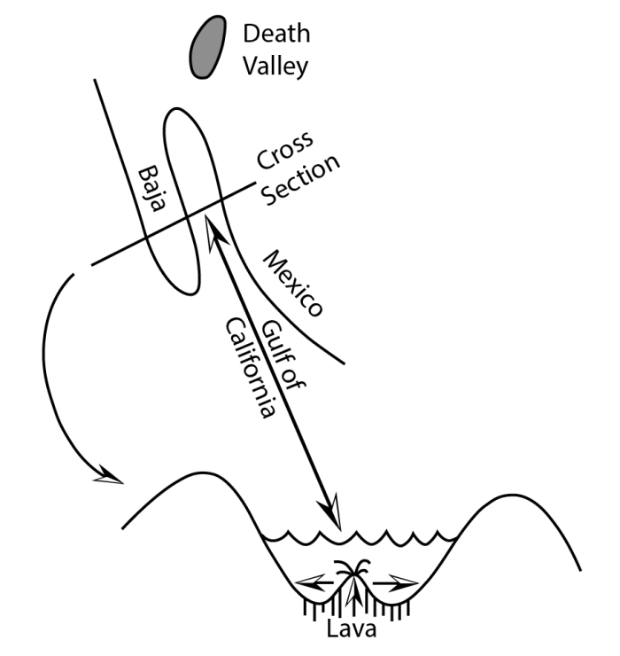
Go south from Death Valley and you will splash into the Gulf of California. The geologic record shows that all of Baja California was attached to the main part of Mexico, but has been moved out to create the Gulf, and is still moving out. Eventually, the Gulf may extend up into Death Valley as the spreading continues and the west “unzips,” although the unzipping may stop before the whole west is opened up (see figure below — Pull-apart fault in the Gulf of California).
Next, boat across the Gulf with a depth-finder running, and you will see that there is a ridge down the middle of the Gulf. Get in your submarine and dive on that ridge, and you will find that it is a volcano. Lava leaks up along a crack in the middle of this ridge volcano, hardens, and then moves slowly away as new lava leaks up along the crack. Interestingly, lava also leaks into Death Valley along its faults, with eruptions within the last 200 to 300 years.
Sea-Floor Spreading
Next, follow this ridge volcano south. You will find that it runs into the open Pacific Ocean and then wraps around the globe through all of the world’s oceans, like the seam on a baseball. The ridge runs right up through the middle of the Atlantic (coming to the surface in Iceland). (Because the ridge is in the middle of the Atlantic, and the middle of the Gulf of Mexico, and the middles of some other ocean basins, it is often called a mid-oceanic ridge, although in some places the ridge is most assuredly not in the middle of the ocean.) Study the seafloor, and you will see that it is made of rocks that are young—they hardened as lava cooled recently—near the ridge, with older rocks—they hardened as lava cooled a long time ago—as you move away in either direction. We will discuss how we learn the ages of rocks later; for now, please accept that the rocks, and the sediments just above the rocks, are progressively older with increasing distance from the ridge.
Everywhere we meet the ridge, it is shallow and hot. The rocks that form at its volcano slowly cool as they move away, contracting and sinking. The ridge is a bizarre place in many ways—water circulates through cracks in the hot rocks, dissolves many chemicals in the rocks, and emerges at “black smokers” where the minerals reprecipitate or “rainout” in the colder ocean as a sort of black dust or as a cone around the emerging water. Many valuable ore deposits were originally formed from the chemical precipitates around these black smokers. An entire ecosystem of tube worms, clams, etc., lives on bacteria that use these chemicals for a fuel source, rather than relying on the sun for energy as do most living things.
Heat Inside the Earth
We just discussed a lot of observations—a baseball-seam volcano through all the world’s oceans that is making seafloor and splitting and spreading continents and ocean basins. Explaining these observations will tell us much about the Earth and how it works.
The existence of volcanoes, bringing melted rock up from below, tells us that the Earth is hotter inside than at the surface. We learn the same in deep mines and drill holes—the Earth is warmer towards the center (once you get below the top thirty feet or so that are warmed a little by the summer and cooled by the winter). All rocks contain radioactive elements (mostly uranium, thorium, and radioactive potassium, but with some others). Radioactive decay of these makes heat in the Earth, much as radioactivity produces heat in nuclear power plants. Most of the Earth’s heat comes from this radioactive decay, although some heat is left over from when the Earth formed, or is being released as the core freezes, or the core, mantle, and crust continue to separate and things sink and give up heat from friction.
Heat is just vibration of the atoms of which everything is made. More heat causes more vibration. Temperature is a measure of these vibrations; more vibration gives a higher temperature.
Heat is moved around in three main ways: radiation, conduction, and convection. Vibrating atoms give off electromagnetic radiation. The electromagnetic radiation that comes from very hot atoms is visible to us and is called light; cooler atoms give off infrared or other electromagnetic radiation we cannot see. When an atom gives off electromagnetic radiation, the atom cools and slows down, unless it receives other energy to speed it up again. You soak up electromagnetic radiation if you lie out in the sun (and may get skin cancer as it damages the DNA in your skin), and you can feel electromagnetic radiation if you hold your hand off to one side of a hot stove burner. Electromagnetic radiation is a very efficient way to move heat from the sun to the Earth through space and our atmosphere, but radiation is a very inefficient way to move heat through rocks—the radiation doesn’t get very far before it is absorbed. (Thus, you cannot see far through most rocks.)
If a rapidly vibrating atom (a hot one) sits next to a slowly vibrating atom (a cold one), collisions between the two will tend to slow down the fast one and speed up the slow one. This process is called conduction and moves heat energy from atom to atom. Conduction is a very rapid process over short distances. (If you foolishly touch a hot stove burner, you will almost instantly realize how quickly it makes the atoms in your skin vibrate rapidly, and how much damage can be done if they vibrate too rapidly and jump out of those places where they are supposed to be in your skin.) Conduction is a very slow process over long distances. Think of standing in a line of 1000 people. If you push your neighbor, the response is almost immediate. But if you wish to disturb someone at the other end of the line, pushing your neighbor who pushes her neighbor who pushes his neighbor… it becomes very inefficient. For the Earth, the distance from the center to the surface is about 10,000,000,000,000,000 atoms. The Earth is not old enough for heat trapped at its center when it formed to have been conducted to the surface.
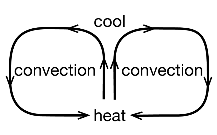
Convection is the third option for moving heat. Take something hot, and move it from here to there. To get heat from the stove to your dinner table, you cook things on the stove and then carry them to the table, which is much more efficient than putting the food on the table and waiting for conduction or radiation to bring heat from the stove.
Nature has a special way to arrange this motion in many things. Heating causes almost all materials to expand, because hotter molecules vibrate more rapidly and tend to bounce farther away from each other. This lowers the density of the material; its mass is the same, but it takes up more room. Low-density materials tend to rise, and high-density materials to sink. This leads to convection currents—a material is heated, rises, cools and sinks. Typically, rising occurs in one place, the material flows along while it cools, then it sinks and flows back to the rising point (see the convection figure above). (Technically, moving heat by rising of materials that expanded when they were heated is called “convection,” and moving heat by transferring hot materials in other ways is called “advection,” but introductory texts usually call it all “convection.”) You should have seen the effects of convection currents in the air (we’ll talk about them later, but they produce wind, rain, etc.), and in the boiling water of a pot of spaghetti on the stove. We believe that convection currents occur in the Earth as well. This may seem odd at first, because most of the Earth is solid rather than liquid. (Volcanoes come from a depth where there is a little bit of liquid, but even there most of the rock is solid.) However, sufficiently hot rocks are soft enough to flow slowly. Again, we will discuss this later, but it is the same principle that allows a blacksmith to work hot iron into horseshoes, or allows a chocolate bar to droop on a hot day.
Our modern picture of the Earth, then, is that it is heated inside, mostly by radioactivity. That heat cannot escape easily by radiation or conduction. When the Earth was young, the heat stayed in and warmed the planet. When the rocks became hot enough, they began to convect. The planet probably melted completely and convected vigorously, followed by solidification that slowed but did not stop the convection.
In convection, the hotter rocks rise and then spread. Rising occurs beneath the ridges in the oceans. There, the new seafloor is made, and then rafted away on the spreading convection cells. Where a spreading zone passes under a continent, the continent is thinned and stretched, and may be torn apart to make a new ocean. This is occurring under East Africa in the rift valleys, and in the Basin and Range of the western United States—including Death Valley—and occurred to open the Gulf of California, moving Baja away from the mainland. (There may be convection cells stacked on top of each other in the mantle, and other complexities—if we tried to cover all of the wonderful complexity in an introductory course, some of you would be overjoyed but many of you would be unhappy—but this is a good start.)
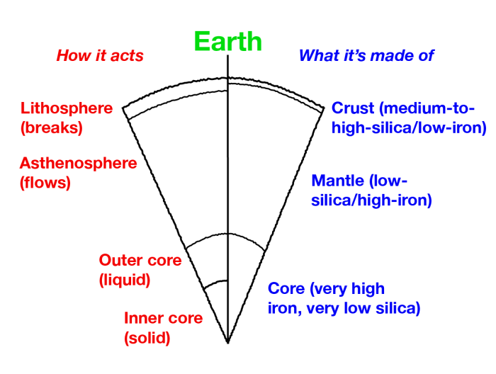
The Earth is layered chemically into a medium-to-high-silica crust, a low-silica mantle, and an iron core (well, there’s a good bit of nickel in the core, too). The Earth is also layered based on its ability to flow rather than break (see the Cross section of the Earth figure on the right). The lithosphere includes the crust and upper mantle. The lithosphere can flow a little in some places, but usually breaks rather than flowing if you hit it or squeeze it or pull it with sufficient vigor. Below the lithosphere, the asthenosphere is that part of the mantle that flows rather than breaking, and from which many spreading-ridge volcanoes come. The topmost layer of the mantle is the bottom part of the breaks-rather-than-flows lithosphere. Below this in the mantle is the flows-rather-than-breaks asthenosphere, and then other layers that also flow rather than break, and that we don’t make you learn. And the core has a liquid outer part and solid inner part.
The lithosphere is broken into a few basic pieces called plates. These float around on the convecting, soft asthenosphere. A plate may include just continental rocks, or just sea floor, or some of each. A plate map is given in chapter 3, in section 3.2 on Olympic National Park. The study of these plates and how they move and interact with each other is called “plate tectonics.”
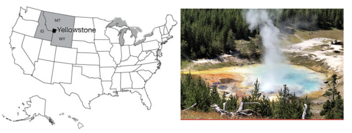
Yellowstone is Shaking – Real-world Applications: Yellowstone and Earthquakes
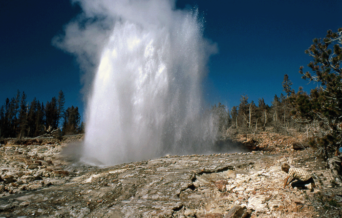
Credit: Left: R.B. Alley © Penn State is licensed under CC BY-NC-SA 4.0. Right: Imperial Geyser looking south, Yellowstone by Pat Shanks, Volcano Hazards Program, U.S. Geological Survey (USGS) (Public Domain)
Yellowstone: for many people, the name is synonymous with national parks. Yellowstone was the first national park, for a while it was the biggest (at approximately 60 miles by 60 miles—100 km by 100 km—it is still a big one), and it is widely considered to be the best. You could probably identify a dozen features or more that, separately, would merit protection by a national park. The Grand Canyon of the Yellowstone is a great chasm cut through volcanic rocks that have been “cooked” by hot water and steam circulating through them, in the process gaining the yellow color that gave the park its name. The Canyon contains two large waterfalls (rather unimaginatively called the Upper and Lower Falls), where the river plunges over more-resistant rocks. Mammoth Hot Springs is a mountain being turned inside-out, with acidic hot-spring waters dissolving caves underground, bringing the dissolved limestone to the surface, and depositing some of it as gleaming terraces. Specimen Ridge is home to at least 20 petrified forests complete with petrified roots, standing one on top of the other, from roughly 40 million years ago. Volcanic ash and debris flows buried the standing trees, and chemical reactions caused the silica in the ash to move into the wood, replacing it (a subject for much later in the course). A new forest grew, was buried, and this repeated 20 or more times.
The biggest draws at Yellowstone are the thermal features. Various lines of evidence indicate that there is a body of melted rock (magma) under the park, now up towards the northeast side. The rocks under most of the park are anomalously hot at shallow depth. In addition, the park receives abundant rainfall and snowfall. The water from rain and melted snow circulates deeply through rocks broken by numerous earthquakes, and the water is heated from below. In some places, the water is heated all the way to steam, which emerges from holes known as fumaroles. In other places, hot water bubbles to the surface in beautiful springs. If the bubbling action mixes in enough mud, then paint pots, mud pots or mud volcanoes develop.
Sometimes, cold water on top holds hot water down, with the pressure preventing boiling of the hot water in a pressure-cooker effect. Eventually, a little boiling manages to expel a little of the water above, reducing the pressure, allowing more boiling, and a geyser erupts. Geysers require heat, water, and a tight, tough plumbing system to hold the hot water and withstand the high pressures. The volcanic rocks of Yellowstone are rich in silica, which is dissolved and re-precipitated by the hot waters to seal cracks in the rocks, helping produce geysers. Perhaps half of the world’s geysers are in Yellowstone, including the largest and most spectacular ones. Yellowstone also is noted for many waterfalls besides those in the Canyon, for a number of other interesting features, and for abundant wildlife, which we’ll visit later in the course.
Yellowstone itself is centered on the Yellowstone Caldera, a collapse feature related to three great volcanic eruptions, or periods of eruptions. The caldera, roughly 50 x 30 miles (80 x 50 km), includes Yellowstone Lake but extends well beyond it. (No lake in the nation is both higher and larger than Yellowstone Lake, yet it is only a piece of the caldera.) The eruptions occurred roughly 1.8, 1.2, and 0.6 million years ago. Each of these eruptions moved roughly 1000 times more material than did the Mt. St. Helens eruption of 1980 that we will discuss soon; thick deposits erupted from Yellowstone are known from the Badlands region of South Dakota. The erupted material that spread across South Dakota was removed from a magma chamber, and after removal, the “top fell in” to create the large depression that is the caldera.
Yellowstone has many lessons to teach us. (Some year, it would be fun to have a course on the geology of Yellowstone alone, and we certainly could fill a semester.) The size of the Yellowstone eruptions is of considerable interest, especially considering the likelihood that they will recur. Here, we wish to use Yellowstone to introduce earthquakes.
European exploration of the Yellowstone region probably began with “mountain man” John Colter during his return from the Lewis and Clark expedition in 1806, although Native Americans had used the region for thousands of years before. Colter brought back fantastic tales of the region, which were largely dismissed because they seemed impossible. Other travelers, and especially Jim Bridger in the 1850s, returned with similar tales, which also were discounted, in part because Bridger was a bit of a tall-tale teller. He is credited with stories of petrified birds sitting on petrified trees singing petrified songs (an exaggerated description of Specimen Ridge), of rivers that ran so fast they became hot on the bottom (the Firehole River, which actually has hot springs on the bottom), of trying to shoot an elk and missing because a mountain of glass was in the way (Obsidian Cliff, where rapidly-cooled volcanic rocks have made a glass called obsidian, which was mined, shaped, and traded by the native Americans), and more.
To separate fact from fancy, the Washburn expedition from Montana (Washburn was surveyor-general of the Montana Territory) visited the region in 1870, and first developed the idea of a national park. The government-sponsored Hayden expedition of 1871 provided scientific documentation of the wonders of Yellowstone, supported by the artwork of Thomas Moran and photography by W.H. Jackson, which convinced Congress to found the park in 1872.
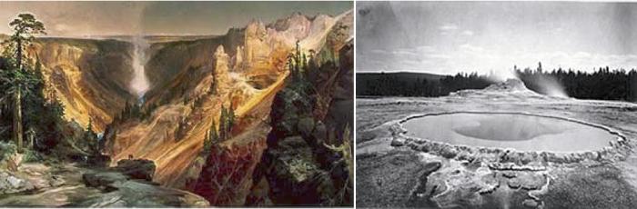
Credit: Thomas Moran, National Park Service (NPS) (Public Domain) and William Henry Jackson, National Park Service (NPS) (Public Domain)
While in the park, the Washburn party felt earthquake activity. Breaks in recent stream and glacier deposits showed the geologists of the party that faulting had occurred recently, and motion on faults produces earthquakes. Since then, modern monitoring equipment has detected numerous quakes in the area.
On August 17, 1959, a Richter-magnitude 7.5 quake occurred, centered near the northwestern boundary of the park. Many of the geysers were changed, and a new one (Seismic Geyser) suddenly began to erupt. The ground over the quake (at the epicenter—the place above the center of the quake) was broken, with one side dropped roughly 6 feet (2 meters) relative to the other side, and with a little twisting and turning causing even larger drops in some places. A large landslide was triggered, burying a campground, damming the Madison River to form Quake Lake, and burying many highways. 28 people were killed. Some survivors had their clothes literally torn off by the immense blast of wind pushed out of the way by the huge landslide. The Old Faithful Inn was evacuated, and the west entrance to Yellowstone closed. The University of Utah’s Seismograph Station has a nice summary of the press reports. You may find it interesting to search for and read the report from the Billings Gazette that a beauty pageant was going on in the historic Inn with 800 people watching, and that “Moments after the queen had been crowned and she was walking down the aisle to the plaudits of the crowd, the first, mighty shock hit. Every one in the place dashed for the door.”
Elastic Rebound Theory
An earthquake is just the shaking of the ground, and many things can cause earthquakes. Much effort has been devoted to detecting underground nuclear tests by the earthquake waves produced. Mining cave-ins, conventional explosions, and other events can cause earthquakes. The deepest earthquakes, which are very rare but often among the biggest ones, may have a phase-change or “implosion” origin, which we’ll discuss later.
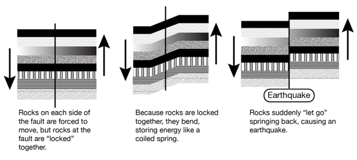
However, most earthquakes are produced by elastic rebound. We’ve already seen that rocks are moving around on the planet, and that the pull-apart action has allowed Death Valley to drop down. We will see that other motions occur as well, with one group of rocks moving past another. Where rocks are warm and soft, they flow. Where cold and hard, they cannot flow.
Consider, for example, two large pieces of rock, such as southwestern California and the rest of the state. The southwestern part of the state, from Los Angeles to San Francisco, and the adjacent ocean floor are moving northwest relative to the rest of the state. The break separating the different parts is called the San Andreas Fault. (Both sides are moving westward, but the southwest side has an additional bit of northwesterly movement relative to the northeast side. Faults may go east-west, or north-south, or any other direction, may be vertical or angled, and the rocks may move vertically or horizontally or in-between across the fault.) The forces that move the rocks are huge and applied over large areas, so that far from the fault the motion is smooth. But at the fault, rough patches can get stuck against each other and become locked for a while. The rocks then bend. This bending is elastic—it can spring back. Eventually, the stress on the rough spots becomes too great, the fault “lets go”, and the bent rocks “spring back”. The springing back is very rapid, in the same way as for a spring or a rubber band. Displacements of several feet (more than a meter) or more are possible in much less than a second. A building sitting on the rocks near the fault can be subjected to very large accelerations, and may fall apart.
Such an earthquake will shake rocks beyond a fault. This is achieved through seismic waves—one piece of rock pushes another next to it, which pushes one next to it, and so on. Two major types of seismic waves are P or push, and S or shear. The P-wave is the ordinary sound wave. It represents a push-pull in the direction the wave is moving. A P-wave moving to the north will shake a mineral grain north-south-north-south. An S-wave moves slower than the corresponding P-wave. When an S-wave moves to the north, the mineral grains are shaken east-west-east-west or up-down-up-down (or some combination). A shear wave is similar to the wave you generate by shaking a rope. A piece of the rope moves up and down or back and forth, but the wave moves along the rope. The “wave” at football games is the same way—you stand up and sit down, but the wave moves along the bleacher bench. A P-wave may start a building shaking in one way, and then the S-wave hits the building and starts shaking it a different way, making the building more likely to break and fall down. (Earthquakes also make surface waves, which move more slowly than shear waves and go along the surface of the Earth like wind-driven waves on the ocean, rather than going through the Earth the way P- and S-waves do. The surface waves can also contribute to breaking buildings.)
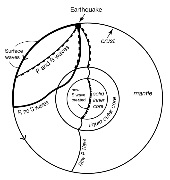
S-waves don’t travel through liquids at all. (Wiggle one piece of liquid to the side, and the moving piece slides freely past the next piece rather than wiggling it.) Recall that earlier we claimed that the outer core of the Earth is liquid. You may have asked “How does anyone know that?” The answer is that, after a really big earthquake, P-waves can be detected all over the Earth. But S-waves are missing across the Earth from the quake, in places reachable only by passing through the core, as shown by the figure. So we know that the outer core is liquid, because it transmits P-waves but not S-waves. And the outer core is nearly spherical, because no matter where an earthquake occurs on the planet, there is a zone on the other side of the Earth in which S-waves are absent. (Learning that the inner core is solid is tougher; one of the pieces of evidence is based on wave conversions. The P-wave that passes through the outer core loses some energy in making an S-wave when the P-wave hits the inner core; this S-wave passes through the solid inner core, makes a new P-wave when it hits the liquid outer core again, and that P-wave travels on to the surface. The delay associated with the slower motion of the S-waves allows this to be figured out. But don’t worry about wave conversions, or the other evidence for a solid inner core, in an introductory course such as this one.)
Where Quakes Occur
Earthquakes, as noted above, occur where rocks are moving past other rocks. We have seen that this happens where rocks are being pulled apart, as in Death Valley, because the breaks often are angled rather than vertical, and the upper side slides down over the lower. We will see that there are other situations in which rocks are being pushed together, or that rocks are sliding past each other as at the San Andreas Fault, and these also can make quakes. This mostly occurs near plate boundaries. Volcanoes can cause small-to medium-sized quakes as well, when moving melt pushes rocks aside or leaves spaces into which rocks fall.
Quakes also occur at weak spots in continents. Often, when a continent is splitting open at a spreading ridge, the tear assumes a 3-armed form, something like the Mercedes-Benz logo. (Poke your finger through a piece of paper and you’ll often get the same thing.) Two arms then grow into a spreading ridge that forms an ocean, and the third arm fails. Major rivers often form in such failed rifts. When the Americas split from Africa and Europe as the Atlantic Ocean grew, failed rifts became the river beds of the Amazon, the Niger and the Mississippi. You open a fast-food ketchup packet by tearing at a little notch cut in the foil, because the notch weakens the foil. If the notch isn’t there, you may have to poke a fork through, or end up saying bad words, because the packet is much harder to tear without the pre-existing notch. In the same way, earthquakes can occur at the tips of failed rifts, which are the “notches” in the “foil” that is the lithosphere of the Earth. Some of the largest quakes known to have occurred in the U.S. were located at the northern tip of the rift along which the Mississippi flows, near New Madrid, Missouri. Quakes also are known from an old weakness near Charleston, South Carolina.
Size of Earthquakes
There are several ways to measure earthquake size. The commonest is the Richter scale, a measure of how much the ground shakes during a quake. Richter developed a logarithmic scale—a magnitude 2 quake shakes the ground 10 times more than does a magnitude 1 quake, and a magnitude 3 quake shakes the ground 10 times more than does a magnitude 2 or 100 times more than does a magnitude 1. You may think of the number of zeros after the 1: if the ground motion of a magnitude 1 quake is 10 (you can choose the units you use, or the distance from the quake at which you measure, to get a motion of 10), then at the same distance from the quake in the same units, a magnitude 2 moves the ground 100 (two zeros), a magnitude 3 moves the ground 1000 (three zeros), a magnitude 0 moves the ground 1 (zero zeros), a magnitude -1 moves the ground 0.1, and so on.
The ground motion can be measured with special instruments called seismographs. Scientists usually look at either P-waves or surface waves to get the size of the quake. The motion must be corrected for distance from the quake; the farther away from the quake your seismograph is, the smaller the ground motion you will measure. Distance can be calculated from the difference in arrival time between the first P-wave and the first S-wave from the quake to reach the instrument, using the difference in speed between P- and S-waves, or by timing the arrival of the earthquake waves at three or more stations, and determining where the quake must have been so that the waves arrived earlier at this station than at that one.
A Richter magnitude 1 quake is just big enough to feel if you are standing on the ground very near where the quake occurs. Magnitude 3 or 4 quakes are usually strong enough to convince some people to call the police (although it is not obvious what these people want the police to do), and magnitude 5 quakes usually cause some damage. The largest known quakes, around 9, each release about 10,000 times the energy of the first atomic bombs.
Small quakes are very common and large quakes rare—one or more years may pass between one magnitude-8 quake and the next one anywhere on the planet. Approximately, each increase in magnitude of 1 causes a 10-fold decrease in frequency of occurrence. But, moving the ground 10 times more takes about 30 times more energy, so most of the energy release and the damage is by the few big quakes rather than by the many little ones.
Predicting Earthquakes
A tremendous amount of effort has gone into trying to predict earthquakes. This is because they are so destructive of life and property. Seventeen quakes are estimated to have killed more than 50,000 people each, and the worst, in Shaanxi, China in 1556, is estimated to have killed over 800,000. (In the U.S.A., the worst death toll was 503 in the San Francisco quake of 1906.) The magnitude 9.0 Tohoku earthquake in Japan in 2011 killed over 15,000 people, although the toll would have been far, far worse if the Japanese had not put so much effort into making strong buildings and otherwise planning to reduce the damages. Earthquakes usually kill by dropping pieces of broken buildings on people, but also by triggering tsunamis (big waves) or landslides, and by breaking gas lines or other things that cause fires.
The easiest way to “predict” quakes is to identify those places where quakes are likely to occur. This can be done from historic records, and from prehistoric geologic evidence. A pattern of landslides of a single age in a region, or of drowned forests related to land subsidence, may indicate the effects of an earthquake. Once people know where quakes are likely, appropriate zoning codes for buildings can be enacted. Spending a million dollars on special engineering for a building to survive quakes is wise indeed near the San Andreas Fault, and really helped Japan, but may not be necessary in State College, Pennsylvania, where big quakes are considered to be highly unlikely.
Other ideas have been advanced for predicting quakes. One is to use patterns of seismicity. If one section of a fault has had a quake every 20 years for the last century, you might expect another quake 20 years after the most recent one. Also, a fault that is slipping and moving may have lots of little quakes, whereas a locked fault that is building to a big quake may have no little quakes. So you could use such a no-quake “seismic gap” in predictions. Such a pattern—historical repeats and a seismic gap—was used recently to predict a quake near Parkfield, CA on the San Andreas Fault. The prediction failed miserably. The possible explanation is that there are many faults in that part of California, and several big quakes occurred on faults near the San Andreas shortly before the expected quake. These certainly perturbed the state of stress at Parkfield, at least delaying its quake. (The other quakes allowed rocks to move, and even caused some faults to run backwards compared to their normal behavior for a while, taking the load off and delaying the next quakes.) This illustrates the difficulty of predicting quakes. Perhaps, if the motions of all of the important blocks were monitored, one could model the whole system and do a better job of predicting where stresses are accumulating. Such work is ongoing, but results are not yet in.
Even if pattern-predictions of earthquakes can be made to work, the predictions are unlikely to be precise enough to really tell us what we want. Knowing that a quake will occur sometime in the next few years, or even the next few days, does not allow us to get people out of old buildings, off bridges, etc., during the quake. The best hope for predictions within hours or minutes is to find premonitory events. As the stresses build toward failure, rocks may begin to crackle, groundwater may move around in the cracks so that water rises in some wells and falls in others, electric signals may be given off by the cracking rocks, animals may act strangely. The difficulty is that groundwater rises and falls in wells for many reasons, strange actions in an animal may indicate bad feed, mating season, or any number of other causes, and other premonitory events of earthquakes also have non-earthquake causes. The subtle clues to an earthquake may be recognized using 20/20 hindsight, but no one has figured out how to read them in advance. The possibility is there, though, waiting for brilliant insights and hard work by some interested researchers. (After a big quake, lots of people show up claiming that they predicted it, but none of these “predictions” has ever been verified. And, many people, including some scientists, have made predictions of particular earthquakes to come, but again, these predictions have not proved to be useful.)
Geomations
Death Valley Animation
The great depth of Death Valley was not excavated by a steam shovel or an atomic bomb, nor were the rocks ground down by rivers, wind, or glaciers. Death Valley was dropped, as the sides of the valley were pulled apart as part of the great motions of the planet’s rocks. High drama indeed. Here is a brief description:
Death Valley Animation
Transcript: Sierra Nevada Mountains, big, beautiful mountain range sitting way the heck up there. Got gimongous trees growing on top of it, and so you’re going to tell that this is a slice that I am showing you through the mountain range, and then bang, down into Death Valley, way down, deep, hot, starkly, gloriously beautiful place. Place you desperately do not wish to be in the summer without your water bottle. But then there’s another range, and another valley, and another range, all the way across Nevada, many more than shown here. And eventually, up in the Wasatch in Utah, end up where you’ll find all these skiers standing around. That’s Snowbird, so here’s a skier so you can remember that this is Snowbird.
And so this is a picture of the west. If, however, you could see underground, what you would find is that there’s a break along the front of the mountains. And that break continues on down. And all of these things have breaks sitting underneath them, running down underground. They’re earthquake faults.
Furthermore, what you would find is that there has been motion, that the mountains have been raised and the valleys have been dropped, the mountains raised and the valleys dropped all the way across here. And for this to be happening, there has to be space made for the valleys to drop into. And so, in fact, the west is getting wider, and that creates the space into which the valleys drop and the mountains raise.
If you were able to find a particular layer of rock that you cared about, you might find it up here, and then you would find it way down below somewhere. And then you’d find it up, and then you’d find it down below, and so on on across. And so it’s a fascinating thing that the west is getting wider. You can measure this with GPS. It’s actually there. It’s shown in the geology, and there’s a big story here.
In addition, one thing that one finds in the west is that there are volcanoes, as well. And those volcanoes tend to come– that blue line– it really should be a red line there– the volcanoes come up, and they often leak up along the cracks, and spout up along the sides like this. And you get pretty little volcanoes growing. And that’s part of the important story of how the west works, as well.
Baja
A person zipped into too-tight pants may “leak out” as the zipper is lowered. Baja California is being unzipped from the mainland of Mexico, and the leak is a volcano making new seafloor. If the unzipping continues, the sea might someday extend up toward or into Death Valley. Get a good grip on your zipper pull, and let’s go see.
Baja Geomation video
Transcript: So we’re going to slice our way through the earth. We’re gonna drive off of Baja, California, down undersea, and across. And out in the middle, we find this big bridge. And then sitting out there is Death Valley. And then we’re going to come on across and back up onto the coast of Mexico.
And just to make sure it’s clear, this is all under water. So here’s the waves of Baja. If you’re really keen about SCUBA diving, this is a good place to go. And there’s birds flying over the top, and there’s little boats that are floating in the water, so you can see what the thing is.
Now, if you were to measure the motion of this stuff, we’re going to find that it’s doing what we’ve seen elsewhere, which is, there’s a motion going away from this ridge. If we could look very carefully, we would find that there is a volcano underneath this, and so material is leaking up into the cracks and making little volcanoes. And as it comes up in the cracks here, it hardens.
Looking at what’s undersea, you find that there are lots of rocks that hardened in the cracks. And so the whole seafloor is made of these rocks that hardened in the cracks, and the oldest ones are farthest away from the center. So they get older if you go out on either side.
If you were interested in fish poop and wind-blown dust, and things of that sort, you’d find there’s almost none of them on the seafloor very close to the center. And then as you go away, they become more and more common. And that’s because there’s been more time for them to pile up, and very close to the center of the ridge, they just have not had very much time to pile up at all.
Now, you might imagine that this is related to other things. Then you remember that way down in the earth, one finds convection cells. And so you get the convection cells coming up and then spreading aside, and a little bit of leakage is coming up into the crack that it makes, making seafloor. And all of the world’s sea floors are made in this way.
Fault Types
You can push things together, pull them apart, slide them past each other – or some combination of pushing or pulling while sliding. Nature does the same, giving different types of faults, which are found in different geological settings. Here’s a quick look.
Fault Types Video
Transcript: There’s three major fault types that correspond to the three major plate boundary types. And we’re going to look at these. They’re push together, pull apart, and slide past. And so right now, we’re looking at a block of rock. And this block of rock is being squeezed by great tectonic stresses that are pushing on it from the sides. And this block of rock happens to be the place that you decided to build your giant, multi-million dollar McMansion that’s just sitting up there on a hill.
Underneath your beautiful McMansion, there is an interesting yellow layer of rock, which you can follow. Now, we hope that you were smart enough, when you built your McMansion, that you didn’t fail to account for the earthquakes that happen in the place that you built it, because otherwise, you’re going to be an unhappy camper. Because when the earthquake happens, you shove one side above the other in the push together environment, and then your house tends to fall down, and then you’d better know your insurance agent very well. And the layer of rock will be offset in the earthquake. So that is a push together plate boundary.
We also know that there are pull apart plate boundaries that are going to do a different motion pattern. There is a block of rock again. You have gotten the insurance settlement on your McMansion, and you have built a new one, which is sitting up here on the hill. But uh-oh, you didn’t check with your geologist friends, or you didn’t remember your GEOSC 10, and so now you have a fault underneath you.
But it’s a slightly different fault in this case, in the sense that rather than being pushed together, now this one is being pulled apart. If you have a pull apart fault going on, then what you will find is that sometime later, you’re in a Death Valley situation. The earthquake happens. It drops the valley relative to the mountain, and you get an offset that looks something like this.
Your yellow layer of rock is still there. It has still been offset. And again, if you haven’t been careful in your construction, or you haven’t worried too much about things, your house has fallen down and your insurance agent would be a good phone call.
Now, there’s a third possibility. Suppose that you’ve now gone broke because you didn’t have good insurance. You’re flying over the San Andreas Fault, and as you look down at the San Andreas Fault, you see the highway that’s crossing the fault, and you’re very pleased to see your new gas station where you’re working because you have to raise money somehow. And in the middle of your highway, there are these beautiful, really fat dashed yellow lines that you see.
Now unfortunately, if you’re not careful, you may have problems yet again, because the San Andreas Fault has motion going on. And so you come back some time later and the road has been offset, and the offset of the road is not a good thing for you. It came about because of the tendency for the west side of California to move north and the east side of California to move south.
And when it did what it was doing, the cars come driving along. And if a car comes driving along this particular highway and isn’t careful what the car is doing, why, the car will run over the rubble that is left of your gas station after the earthquake. And so these are the three possibilities, the push together, the pull apart, and the slide past earthquakes corresponding to those plate boundaries.
Key Takeaways for Earthquakes
The Earth: It’s hot inside!
- The deeper a mine or oil well is, the hotter it is at the bottom; volcanoes bring up heat from below.
- The earth’s heat made mostly by the decay of natural radioactive atoms in rocks.
- How materials behave depends on what they are (iron, silica, etc.) and on the conditions they are placed in (heat, pressure).
The Earth: Layered by Composition & Behavior
- Iron core, mantle with silica added to iron, ocean crust with more silica, continental crust with still more silica–going up, each layer less dense and floats on layers below.
- Core has solid inner part (higher pressure squeezes to solid) and liquid outer part.
- Crust plus upper mantle (called lithosphere) tend to break not flow; deeper in mantle tends to flow not break (asthenosphere).
- Mantle and crust solid, but with a little melt in few places.
Convection: Moving the Mantle’s Heat
- Heating causes expansion & rising, cooling causes contraction & sinking; together form convection cells in the soft part of Earth’s mantle.
- Lithosphere is broken into a few big plates that raft around on the convection cells.
- Where the lithospheric plates are pulled apart, they tend to break. The breaks often slant down, and one side slides down along the other, making an earthquake fault.
- Death Valley is a great example of convection!
Basin and Range Getting Wider
- Great Basin is moving apart about as rapidly as your fingernails grow (an inch or so per year)–can measure with GPS, etc.
- We find layers of rock offset, and earthquakes still happen and increase that offset.
- Lava may leak up in the cracks to feed volcanoes.
- If this keeps going could tear the west apart to make an ocean basin.
Tear-Apart Makes Oceans
- Baja California is drifting away from the mainland.
- The breaking of the rocks has focused along a rift down the middle of the Gulf.
- For most rocks, pressure tends to make solid, and a drop in pressure favors melting.
- The sea floor is hottest and highest near the rift, forming a mid-oceanic ridge.
- Such ridges wind through Earth’s oceans like the seam on a baseball.
- Ocean-floor rocks are youngest near the ridges, oldest farthest from the ridges.
- Sediment thickens away from the ridges because older rocks have had more time for sediment to accumulate.
- Where ridges come up on land, they are ripping continents apart, as at Death Valley and in the East African rifts.
EARTHQUAKES!
- Ground shaking from any cause.
- Most happen when one block of rocks moving past another block gets stuck for a while, it bends, then breaks loose, and the bend snaps back like a broken rubber band (elastic rebound)
- The break between the two blocks of rocks is called a fault.
EARTHQUAKE: Seismic Waves
- P (push) waves are normal sound waves, go through solid, liquid, gas.
- S (shear) waves slower, don’t go through liquids (know Earth’s outer core is liquid because P but not S waves go through).
- Shake buildings and may knock them down.
EARTHQUAKE SIZE
- Increase of 1 in Richter magnitude means an increase of 10 in ground motion, and an increase of 30 in total energy
- Can just feel magnitude-3 quake, magnitude-5 damages buildings, biggest (about magnitude-9) far bigger than the atom bomb.
EARTHQUAKE DAMAGE
- Can be HUGE (worst ever estimated to have killed 800,000 people, China in 1556).
- We can predict where big quakes are likely.
- Can’t (yet) predict a quake is about to happen.
